Alexander County, North Carolina
Alexander County | |
|---|---|
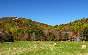
 The Brushy Mountains in Alexander County | |
| Motto(s): "A wonderful place to live, work and play." | |
 Location within the U.S. state of North Carolina | |
 North Carolina's location within the U.S. | |
| Coordinates: 35°55′15″N 81°10′39″W / 35.920951°N 81.177467°W | |
| Country | |
| State | |
| Founded | 1847 |
| Named for | William Julius Alexander[1] |
| Seat | Taylorsville |
| Largest community | Bethlehem |
| Area | |
| • Total | 263.64 sq mi (682.8 km2) |
| • Land | 259.99 sq mi (673.4 km2) |
| • Water | 3.65 sq mi (9.5 km2) 1.39% |
| Population | |
| • Total | 36,444 |
| • Density | 140.17/sq mi (54.12/km2) |
| Time zone | UTC−5 (Eastern) |
| • Summer (DST) | UTC−4 (EDT) |
| Congressional district | 10th |
| Website | alexandercountync |
Alexander County is a county in the U.S. state of North Carolina. In 2020, 36,444 people lived there.[2] Its county seat is Taylorsville.
Government[change | change source]
Alexander County is part of the Western Piedmont Council of Governments.
Connected Counties[change | change source]
These counties are connected to Alexander County:
- Wilkes County, North Carolina - north
- Iredell County, North Carolina - east
- Catawba County, North Carolina - south
- Caldwell County, North Carolina - west
Cities and Towns[change | change source]
These cities and towns are in Alexander County:
References[change | change source]
- ↑ "Alexander County (1847)". www.northcarolinahistory.org. Retrieved June 13, 2022.
- ↑ 2.0 2.1 "QuickFacts: Alexander County, North Carolina". United States Census Bureau. Retrieved January 17, 2024.
Other websites[change | change source]
- Alexander County government official website Archived 2016-04-04 at the Wayback Machine


