
Amersham station
| Amersham | |
|---|---|
 Station entrance | |
 Amersham Location of Amersham in Buckinghamshire | |
| Location | Amersham |
| Local authority | District of Chiltern |
| Managed by | London Underground[1] |
| Station code | AMR |
| Number of platforms | 3 |
| Accessible | Yes (Southbound only)[2] |
| Fare zone | 9 |
| London Underground annual entry and exit | |
| 2017 | |
| 2018 | |
| 2019 | |
| 2020 | |
| 2021 | |
| National Rail annual entry and exit | |
| 2013–14 | |
| 2014–15 | |
| 2015–16 | |
| 2016–17 | |
| Key dates | |
| 1892 | Opened |
| 4 July 1966 | Goods yard closed[9] |
| Other information | |
| External links | |
| WGS84 | 51°40′26″N 0°36′25″W / 51.674°N 0.607°W |
Amersham station is a railway station serving Amersham in Buckinghamshire. It is in Travelcard Zone 9 (previously zone D).
Amerhsam Station is a terminus of the Metropolitan Line branch of the London Underground. It is situated 23.7 miles (38.1 km) north west of Charing Cross and is the second most westerly station on the whole London Underground system, after Chesham[10]
Amersham Station is also served by Chiltern Railways, which runs trains between London Marylebone and Aylesbury. From Aylesbury a shuttle service to Princes Risborough provides access to through services between Marylebone and Birmingham Snow Hill. The journey times to Central London range between 33 and 60 minutes.
Ticket barriers are in operation.
Services[change | change source]
| Preceding station | Following station | |||
|---|---|---|---|---|
| Terminus | Metropolitan line | towards Baker Street or Aldgate |
||
| National Rail | ||||
| Great Missenden | Chiltern Railways Aylesbury route |
Chalfont & Latimer | ||
| Disused railways | ||||
| Great Missenden | Metropolitan Line Until 1961 |
Chalfont & Latimer | ||
Gallery[change | change source]
Wikimedia Commons has media related to Amersham station.
-
 Amersham Station Entrance
 -
 Amersham Station Entrance
 -
 Amersham Station Platform Roundel
 -
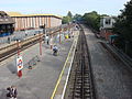
 Amersham Station Platforms
 -
 Amersham Station Platforms
 -
 Amersham Station Platforms
 -
 Amersham Station Platforms


Other websites[change | change source]
- Train times and station information for Amersham station from National Rail
- Official London Underground website
References[change | change source]
- ↑ National Rail Enquiries - Station facilities for Amersham
- ↑ "Step free Tube Guide" (PDF). Transport for London. March 2019. Archived (PDF) from the original on 1 June 2019.
- ↑ "Multi-year station entry-and-exit figures (2007–2017)". London Underground station passenger usage data. Transport for London. January 2018. Archived from the original (XLSX) on 31 July 2018. Retrieved 22 July 2018.
- ↑ "Station Usage Data" (CSV). Usage Statistics for London Stations, 2018. Transport for London. 21 August 2019. Archived from the original on 22 May 2020. Retrieved 27 April 2020.
- ↑ "Station Usage Data" (XLSX). Usage Statistics for London Stations, 2019. Transport for London. 23 September 2020. Archived from the original on 9 November 2020. Retrieved 9 November 2020.
- ↑ "Station Usage Data" (XLSX). Usage Statistics for London Stations, 2020. Transport for London. 16 April 2021. Retrieved 1 January 2022.
- ↑ "Station Usage Data" (XLSX). Usage Statistics for London Stations, 2021. Transport for London. 12 July 2022. Retrieved 7 September 2022.
- ↑ 8.0 8.1 8.2 8.3 "Station usage estimates". Rail statistics. Office of Rail Regulation. Please note: Some methodology may vary year on year.
- ↑ Hardy, Brian, ed. (March 2011). "How it used to be - freight on The Underground 50 years ago". Underground News (591). London: London Underground Railway Society: 175–183. ISSN 0306-8617.
- ↑ "O.S. Map". Archived from the original on 2007-09-30. Retrieved 2009-06-08.
- Butt, R.V.J. (October 1995). The Directory of Railway Stations: details every public and private passenger station, halt, platform and stopping place, past and present (1st ed.). Sparkford: Patrick Stephens Ltd. ISBN 1-8526-0508-1. OCLC 60251199.
- Jowett, Alan (2000). Jowett's Nationalised Railway Atlas (1st ed.). Penryn, Cornwall: Atlantic Transport Publishers. ISBN 0-9068-9999-0. OCLC 228266687.
| Stations |
|   | |||||||||||||
|---|---|---|---|---|---|---|---|---|---|---|---|---|---|---|---|
| Rolling stock |
| ||||||||||||||
| History |
| ||||||||||||||
| Future proposals |
| ||||||||||||||