
Bad Aibling
Bad Aibling | |
|---|---|
 Coat of arms | |
Location of Bad Aibling  | |
 Bad Aibling  Bad Aibling | |
| Coordinates: 47°52′N 12°01′E / 47.867°N 12.017°E | |
| Country | Germany |
| State | Bavaria |
| Admin. region | Upper Bavaria |
| District | Rosenheim |
| Subdivisions | 28 Stadtteile |
| Government | |
| • Mayor | Felix Schwaller (CSU) |
| Area | |
| • Total | 41.55 km2 (16.04 sq mi) |
| Elevation | 492 m (1,614 ft) |
| Population (2022-12-31)[1] | |
| • Total | 19,613 |
| • Density | 470/km2 (1,200/sq mi) |
| Time zone | UTC+01:00 (CET) |
| • Summer (DST) | UTC+02:00 (CEST) |
| Postal codes | 83035 – 83043 |
| Dialling codes | 08061 |
| Vehicle registration | RO (bis 1972 AIB) |
| Website | www |
Bad Aibling (Central Bavarian: Bod Oabling or Oawin) is a town in Bavaria (Germany). It is a former district seat. It is on the river Mangfall about 35 miles southeast of Munich. Bad Aibling is a health resort (peat pulp bath and mineral water).
History[change | change source]

In 804, Bad Aibling was mentioned for the first time. After the second World War Bad Aibling has evolved to a major centre for intelligence organizations and secret services. In 2004 the US American Bad Aibling Echelon station closed after decades of operation. In 2016, ten people were killed in a train crash.
Number of people[change | change source]
In the town live about 18,000 people. It is 498 meters above sea level and covers an area of 41.55 km².
Images[change | change source]
-
 St. Sebastian's church
 -
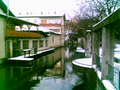 "Klein Venedig" (Little Venice)
 -
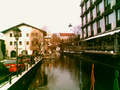 Glonn river in downtown
 -
 View from the "Klafferer" to "Hofberg"
 -
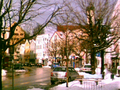 "Kirchzeile" with "Hofberg"
 -
 Obere Kirchzeile
 -
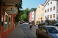
 Inner "Rosenheimer Straße"
 -
 The former Prantshausen castle
 -
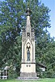 Theresienmonument
 -
 Peat mining in the "Schuhbräu-Filze"
 -
 Italian style central cemetery


References[change | change source]
- ↑ Genesis Online-Datenbank des Bayerischen Landesamtes für Statistik Tabelle 12411-003r Fortschreibung des Bevölkerungsstandes: Gemeinden, Stichtag (Einwohnerzahlen auf Grundlage des Zensus 2011)
Other websites[change | change source]
![]() Media related to Bad Aibling at Wikimedia Commons
Media related to Bad Aibling at Wikimedia Commons