
Blue Lake (South Australia)
| Blue Lake | |
|---|---|
 Blue Lake | |
| Location | Mount Gambier, South Australia |
| Coordinates | 37°50′48″S 140°46′41″E / 37.84667°S 140.77806°E |
| Type | Crater lake |
| Catchment area | Blue Lake Catchment Area |
| Basin countries | Australia |
| Max. length | 1,087 m (3,566 ft) |
| Max. width | 657 m (2,156 ft) |
| Surface area | 70 ha (170 acres) |
| Average depth | 72 m (236 ft) |
| Max. depth | 77 m |
| Shore length1 | None |
| Islands | None |
| Settlements | None |
| 1 Shore length is not a well-defined measure. | |

The Blue Lake is in Mount Gambier, South Australia. It may be a dormant volcanic crater. It is one of four crater lakes on Mount Gambier. Over the past 30 to 40 years the water table has dropped. The Blue Lake changes colour, from grey to bright blue.
Different dates have been given for its last eruption, of 28,000 years ago,[1] 4342 years ago,[2] and, recently, a little before 6000 years ago.[3] If the youngest date is correct, this could be the most recent volcanic eruption on the Australian mainland.
Blue Lake has an average depth of 72 metres, but in places reaches 77 metres deep. The crater rim measures 1,200 metres (3,937 feet) by 824 metres (2,703 feet). The lake itself measures 1,087 metres (3,566 feet) by 657 metres (2,155 feet). The bottom of the lake is 30 metres (100 feet) below the level of the main street of the nearby town. The Blue Lake supplies the town with drinking water.
Major diving exploration of the lake first took place in 1985. Cave diver Peter Horne studied the temperature and visibility of the water. He discovered a fresh water sponge species and other invertebrates.[4]
He also discovered "The stromatolite field", hollow rock formations on the north-eastern edge at a depth of 40 m.[4] In 2008 another dive brought up core samples from the calcite-silt covered lake bed, and measured the water temperature on the lake bed at 14 degrees Celsius (57 °F).
Notes[change | change source]
- ↑ Grimes, Ken (2013). "The ages of our volcanoes" (PDF). Archived from the original (PDF) on 2016-03-04. Retrieved 2013-08-22.
- ↑ "Volcanoes & Earthquakes in SE Australia". University of Western Australia. Archived from the original on 2008-05-10. Retrieved 2008-05-07.
- ↑ Gouramanis, Chris; Wilkins, Daniel; De Deckker, Patrick (2010). "6000years of environmental changes recorded in Blue Lake, South Australia, based on ostracod ecology and valve chemistry". Palaeogeography, Palaeoclimatology, Palaeoecology. 297 (1): 223–237. Bibcode:2010PPP...297..223G. doi:10.1016/j.palaeo.2010.08.005. hdl:1885/53594.
- ↑ 4.0 4.1 Harris, Richard (July–September 2008). "The big blue". Australian Geographic. 91: 34.
Sources[change | change source]
- Sheard M.J. (1978) Geological history of the Mount Gambier volcanic complex, southeast South Australia. Transcript from Royal Society of South Australia 102(5), Aug. 1978
- Telfer A. (2000) Identification of processes regulating the colour and colour change in an oligotrophic, hardwater, groundwater-fed lake, Blue Lake, Mount Gambier, South Australia. Lakes and reservoirs: research and management. 5 161-176.
- Turoczy N.J. (2002) Calcium chemistry of Blue Lake, Mt Gambier, Australia, and relevance to remarkable seasonal colour changes. Archiv fur Hydrobiologia. 156 (1) 1-9.
- Emeny J; Turner G; Turoczy N.J. and Stagnitti F. (2006) The influence of weather and solar elevation on perceived colour of Blue Lake, Mount Gambier, South Australia. Transactions of the Royal Society of South Australia. 130(1) 101-108.
Gallery[change | change source]
-
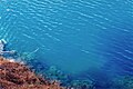
 The Blue Lake in early March.
 -
 The Blue Lake in early March.
 -
 The Blue Lake in early March.
 -
 Approximately 4 metres above the lake's surface.
 -
 The lake in early March with the original pumping station in the foreground.


