
California State Route 1
State Route 1 | ||||
|---|---|---|---|---|
 Map of California with SR 1 highlighted in red | ||||
| Route information | ||||
| Maintained by Caltrans | ||||
| Length | 655.845 mi (1,055.480 km) (broken into 5 pieces by U.S. Route 101) | |||
| Existed | 1934–present | |||
| Tourist routes | ||||
| Restrictions | Special restrictions'[1]
| |||
| Major junctions | ||||
| South end | ||||
| ||||
| North end | ||||
| Location | ||||
| Country | United States | |||
| State | California | |||
| Counties | Orange, Los Angeles, Ventura, Santa Barbara, San Luis Obispo, Monterey, Santa Cruz, San Mateo, San Francisco, Marin, Sonoma, Mendocino | |||
| Highway system | ||||
| ||||

State Route 1 (SR 1) is a major north–south state highway that runs along most of the Pacific coastline of the U.S. state of California.
Highway 1 includes parts called Pacific Coast Highway (PCH), Cabrillo Highway, Shoreline Highway, or Coast Highway. Its southern end is at Interstate 5 (I-5) near Dana Point in Orange County. Its northern end is at U.S. Highway 101 (US 101) near Leggett in Mendocino County. Highway 1 also at times runs together with US 101, through a 54-mile (87 km) stretch in Ventura and Santa Barbara Counties, and across the Golden Gate Bridge.
The highway is famous for running along some of the most beautiful coastlines in the USA. This is why people sometimes call it an 'All-American Road'. In addition to its scenic route to attractions along the coast, it is also a major thoroughfare in the Greater Los Angeles Area, the San Francisco Bay Area, and several other coastal urban areas.
-
 Heading south near Laguna
 -
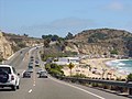
 CA 1 in Ventura County
 -
 Big Sur, Dinosaur Rock & Bixby Bridge
 -
 CA 1 in Big Sur


References[change | change source]
- ↑ "Special Route Restrictions". California Department of Transportation. Retrieved July 25, 2014.
| KML file (edit • help)
|