
Drogheda
Drogheda
Irish: Droichead Átha | |
|---|---|
Town | |
 Lacy bridge | |
 Flag  Coat of arms | |
| Motto(s): | |
 Drogheda Location in Ireland | |
| Coordinates: 53°42′50″N 6°21′1″W / 53.71389°N 6.35028°W | |
| Country | Ireland |
| Province | Leinster |
| County | County Louth |
| Dáil Éireann | Louth |
| Highest elevation | 23 m (75 ft) |
| Lowest elevation | 1 m (3 ft) |
| Population (2011)[1] | 30,435 |
| Irish Grid Reference | O088754 |
| Website | www |
Drogheda (pronounced /ˈdrɒhədə/ or /ˈdrɔːdə/) (Droichead Átha in Irish, meaning "Bridge of the Ford") is an industrial and port town in County Louth on the east coast of Ireland, 56 km (35 mi) north of Dublin.
Within legally defined boundaries, Drogheda is the second largest town in Ireland, behind its county neighbour, Dundalk; however, the town's total population (including suburbs and environs) is recorded to be 35,090, five inhabitants more than Dundalk.[2]
-
 Thosel
 -
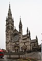 St. Peter
 -
 Magdalene Tower
 -
 St. Laurence Gate
 -
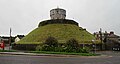 Millmount
 -
 Boyne river


References[change | change source]
- ↑ "Census 2011, Preliminary results", Table 8. Central Statistics Office Ireland
- ↑ "Census 2006 – Volume 1 – Population Classified by Area" (PDF). Central Statistics Office Census 2006 Reports. Central Statistics Office Ireland. April 2007. Retrieved 2007-06-17.
Other websites[change | change source]
- Drogheda Tourism
- Drogheda Borough Council
- Architecture of Drogheda Archived 2008-05-13 at the Wayback Machine
- Photo Survey of Navan Drogheda existing railway line Archived 2007-09-27 at the Wayback Machine
- Drogheda Port
- Drogheda Chamber of Commerce
- IDA Ireland, Drogheda profile Archived 2005-12-20 at the Wayback Machine
- Drogheda's Municipal Art Gallery
- Drogheda United FC
- Droichead Arts Centre Archived 2019-06-17 at the Wayback Machine
Wikimedia Commons has media related to Drogheda.