
Encamp
Encamp | |
|---|---|
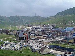
 The town of Encamp and the Valira d'Orient river valley | |
 Flag  Coat of arms | |
 Encamp parish, in red, in Andorra | |
| Coordinates: 42°32′10″N 1°34′58″E / 42.53611°N 1.58278°E | |
| Country | Andorra |
| Capital | Encamp |
| Villages | See list |
| Government | |
| • Mayor | Jordi Torres Arauz |
| Area | |
| • Total | 86 km2 (33 sq mi) |
| Elevation | 1,238 m (4,062 ft) |
| Population (2015)[3] | |
| • Total | 12,212 |
| • Density | 140/km2 (370/sq mi) |
| Demonym(s) | encampadà, encampadana |
| Time zone | UTC+1 (CET) |
| • Summer (DST) | UTC+2 (CEST) |
| Postal code | AD200 |
| ISO 3166 code | AD-02 |
| Website | Official website |
Encamp is one of the seven parishes of Andorra. It is in the east central part of the country. Encamp is also the name of the main town of the parish.
Geography[change | change source]
The Encamp parish is in the east central part of the country and borders with the Canillo parish to the north, with the Pyrénées-Orientales department (France) to the east, with Spain to the southeast, with the Escaldes-Engordany parish to the south, with the La Massana parish to the west and the Ordino parish to the northwest.
Places next to Encamp | |
|---|---|
The highest mountain in the parish is Pic del Pessons (42°30′30″N 1°39′32″E / 42.50833°N 1.65889°E) with an elevation of 2,840 m (9,320 ft) above sea level.[4]
The main river in Encamp is the Valira d'Orient.
Population[change | change source]
The parish had a population, in 2015, of 12,212 inhabitants,[3] for a population density of 142.0 persons/km².
Evolution of the population in Encamp[5]

| 1981 | 1986 | 1991 | 1996 | 2001 | 2006 | 2011 | 2015 |
|---|---|---|---|---|---|---|---|
| 4,231 | 5,766 | 8,680 | 9,800 | 10,627 | 13,685 | 13,521 | 12,212 |
Villages[change | change source]
The urban areas in the parish are:
| No. | Town | Population[6] (2015) |
Altitude[7] (m) |
Notes[7] |
|---|---|---|---|---|
| 1 | Encamp | 7,630 | 1,226 | The capital of the parish. |
| 2 | Les Bons | 1,117 | 1,336 | It is on the right side of the Valira d'Orient river. Here is the Sant Romà church (XII century). |
| 3 | El Pas de la Casa | 2,403 | 2,081 | It is on the border with France. |
| 4 | Vila | 1,062 | 1,328 | Here is the Sant Romà de Vila.[8] |
Economy[change | change source]
The main economic activity is tourism and the parish is a major tourism destination.
Sites of interest[change | change source]
- Sant Romà de Vila church in Vila
- Sant Romà de les Bons church in Les Bons
- Museu Nacional de l’Automòbil d’Andorra, a automobile museum in Encamp
- Santa Eulàlia d'Encamp church in Encamp
- Grandvalira ski resort
Gallery[change | change source]
-
 Encamp town hall
 -
 El Pas de la Casa
 -
 Sant Romà de Vila church
 -
 Sant Romà de les Bons church


References[change | change source]
- ↑ "Equip comunal 2016-2019". Comú d'Encamp (in Catalan). Archived from the original on 2 April 2015. Retrieved 27 December 2016.
- ↑ "Encamp" (in Catalan). Enciclopèdia Catalana. Retrieved 27 December 2016.
- ↑ 3.0 3.1 "Population by parish". Department d'Estadísticas - Govern d'Andorra. Archived from the original on 24 September 2015. Retrieved 27 December 2016.
- ↑ "Pic de Pessons, Andorra". Peakbagger.com. Retrieved 27 December 2016.
- ↑ "Population by parish (1981-2016)". Department d'Estadísticas - Govern d'Andorra. Retrieved 21 August 2017.[permanent dead link]
- ↑ "Population by town". Department d'Estadísticas - Govern d'Andorra. Retrieved 27 December 2016.[permanent dead link]
- ↑ 7.0 7.1 "Enciclopèdia Catalana" (in Catalan). Grup Enciclopèdia Catalana. Retrieved 27 December 2016.
- ↑ "Església de Sant Romà de Vila" (in Catalan). Govern d'Andorra - Cultura. Retrieved 27 December 2016.