
Escaldes-Engordany
Escaldes-Engordany | |
|---|---|
 View of Escaldes-Engordany | |
 Flag  Coat of arms | |
 Escaldes-Engordany parish, in red, in Andorra | |
| Coordinates: 42°30′32″N 1°32′27″E / 42.50889°N 1.54083°E | |
| Country | Andorra |
| Capital | Escaldes-Engordany |
| Urban areas | See list |
| Government | |
| • Mayor | Trini Marín |
| Area | |
| • Total | 30 km2 (10 sq mi) |
| Elevation | 1,050 m (3,440 ft) |
| Population (2015)[2] | |
| • Total | 14,367 |
| • Density | 480/km2 (1,200/sq mi) |
| Time zone | UTC+1 (CET) |
| • Summer (DST) | UTC+2 (CEST) |
| Postal code | AD700 |
| ISO 3166 code | AD-07 |
| Website | Official website |
Escaldes-Engordany is one of the seven parishes of Andorra. It is in the southeast of the country. Escaldes-Engordany is also the name of the main town of the parish.
History[change | change source]
The Escaldes-Engordany parish was created in 1978 with part of the territory of the Andorra la Vella parish with two urban areas: Escaldes and Engordany. With time, these two towns were combined to form the present capital of the parish.
Geography[change | change source]
The Escaldes-Engordany parish is in the southeast of the country and borders with the Encamp parish to the north, with the Sant Julià de Lòria parish to the southwest, with the Andorra la Vella parish to the west and the La Massana parish to the northwest. Spain is to the east and south of the parish.
Places next to Escaldes-Engordany | ||||||||||
|---|---|---|---|---|---|---|---|---|---|---|
| ||||||||||
The highest mountain in the parish is Tossa Plana (42°28′5″N 1°39′26″E / 42.46806°N 1.65722°E) with an elevation of 2,904 m (9,528 ft) above sea level.[3] It is in the southeast of the parish, on the border with Spain.
The main rivers in Escaldes-Engordany are the Valira del Nord and the Valira d'Orient; they form the Gran Valira after their confluence in Escaldes-Engordany. Other river is the Madriu.
The town of Escaldes-Engordany is the capital of the parish; it is in the northwest of the parish, close to the town of Andorra la Vella, forming the largest urban area of the country.
Population[change | change source]
The parish had a population, in 2015, of 14,367 inhabitants,[2] for a population density of 478.9 persons/km².
Evolution of the population in Escaldes-Engordany[4]

| 1981 | 1986 | 1991 | 1996 | 2001 | 2006 | 2011 | 2015 |
|---|---|---|---|---|---|---|---|
| 10,412 | 11,734 | 12,772 | 15,182 | 15,519 | 16,391 | 14,395 | 14,367 |
Villages[change | change source]
The urban areas in the parish are:
- Escaldes-Engordany, the main urban area of the parish; it is formed by:
- Les Escaldes, or just Escaldes, at an altitude of 1,053 m (3,455 ft). The name Les Escaldes comes from the presence of numerous hot springs, which produce highly sulphurous and nitrogenous waters at temperatures between 22 and 66 °C (72 and 151 °F).[5] The hot springs were known by the Romans who used them for medical purposes,[5] and now are used in "Caldea", a spa.
- Engordany, at an altitude of 1,109 m (3,638 ft) on the right side of the Valira d'Orient river, on the foot of the Pic de Padern mountain (1,861 m (6,106 ft) high).[6]
- Els Vilars d'Engordany, to the north of Engordany. Here is the Sant Romà dels Vilars chapel of the X century, at an altitude of 1,861 m (6,106 ft) on the foot of the Pic de Padern mountain.[7]
- Engolasters at about 2 km (1.2 mi) to the east of Andorra la Vella, at an altitude of 1,504 m (4,934 ft).[8]
Economy[change | change source]
The main economic activity is tourism and the parish is a major tourism destination.
Sites of interest[change | change source]
- Sant Romà dels Vilars church in Els Vilars d'Engordany
- Sant Miquel d'Engolasters church in Engolasters
- Pont d'Engordany, a bridge built in 1785[9]
- Pont dels Escalls, a bridge[10]
- Caldea, a spa in Les Escaldes
Gallery[change | change source]
-
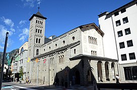 Sant Pere Màrtir church
 -
 Sant Miquel d'Engolasters church
 -
 Sant Romà dels Vilars church
 -
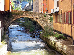 Pont d'Engordany bridge over the Valira river


References[change | change source]
- ↑ "Equip comunal". Comú d'Escaldes-Engordany (in Catalan). Retrieved 26 December 2016.
- ↑ 2.0 2.1 "Population by parish". Department d'Estadísticas - Govern d'Andorra. Archived from the original on 24 September 2015. Retrieved 25 December 2016.
- ↑ "Tossa Plana, Andorra". Peakbagger.com. Retrieved 27 December 2016.
- ↑ "Population by parish (1981-2016)". Department d'Estadísticas - Govern d'Andorra. Retrieved 21 August 2017.[permanent dead link]
- ↑ 5.0 5.1 "les Escaldes" (in Catalan). Enciclopèdia Catalana. Retrieved 27 December 2016.
- ↑ "Engordany" (in Catalan). Enciclopèdia Catalana. Retrieved 27 December 2016.
- ↑ "el Vilar d'Engordany" (in Catalan). Enciclopèdia Catalana. Retrieved 27 December 2016.
- ↑ "Engolasters" (in Catalan). Enciclopèdia Catalana. Retrieved 27 December 2016.
- ↑ "Pont d'Engordany" (in Catalan). Govern d'Andorra. Retrieved 27 December 2016.
- ↑ "Pont dels Escalls" (in Catalan). Govern d'Andorra. Retrieved 27 December 2016.