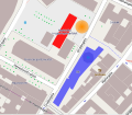
File:2011 Oslo attacks map.svg

Size of this PNG preview of this SVG file: 603 × 524 pixels. Other resolutions: 276 × 240 pixels | 552 × 480 pixels | 884 × 768 pixels | 1,178 × 1,024 pixels | 2,357 × 2,048 pixels.
Original file (SVG file, nominally 603 × 524 pixels, file size: 516 KB)
File history
Click on a date/time to view the file as it appeared at that time.
| Date/Time | Thumbnail | Dimensions | User | Comment | |
|---|---|---|---|---|---|
| current | 10:36, 23 July 2011 |  | 603 × 524 (516 KB) | Beao | Minor positioning. |
| 10:34, 23 July 2011 |  | 603 × 524 (516 KB) | Beao | {{Information |Description={{en|1=Map over the ''2011 Oslo attacks''. <br>''Red building'': Government building.<br>''Orange area'': Position of the remains of the exploded car.<br>''Blue building'': Oil Ministry building.}} |Source=*[[:File:2011_Oslo_att |
File usage
The following page uses this file:
Global file usage
The following other wikis use this file:
- Usage on be-tarask.wikipedia.org
- Usage on be.wikipedia.org
- Usage on bg.wikipedia.org
- Usage on bs.wikipedia.org
- Usage on ckb.wikipedia.org
- Usage on cs.wikipedia.org
- Usage on da.wikipedia.org
- Usage on eo.wikipedia.org
- Usage on eu.wikipedia.org
- Usage on fa.wikipedia.org
- Usage on fi.wikipedia.org
- Usage on fr.wikipedia.org
- Usage on hr.wikipedia.org
- Usage on hy.wikipedia.org
- Usage on it.wikipedia.org
- Usage on ja.wikipedia.org
- Usage on ko.wikipedia.org
- Usage on la.wikipedia.org
- Usage on mzn.wikipedia.org
- Usage on pl.wikipedia.org
- Usage on pt.wikipedia.org
- Usage on ru.wikipedia.org
- Usage on ru.wikinews.org
- Usage on sr.wikipedia.org
- Usage on th.wikipedia.org
- Usage on uk.wikipedia.org
- Usage on www.wikidata.org
- Usage on zh.wikipedia.org
