
File:Aires linguistiques du nord-est algérien.svg

Size of this PNG preview of this SVG file: 800 × 482 pixels. Other resolutions: 320 × 193 pixels | 640 × 386 pixels | 1,024 × 617 pixels | 1,280 × 772 pixels | 2,560 × 1,544 pixels | 1,461 × 881 pixels.
Original file (SVG file, nominally 1,461 × 881 pixels, file size: 114 KB)
| This is a file from the Wikimedia Commons. Information from its description page there is shown below. Commons is a freely licensed media file repository. You can help. |
Summary
| Description |
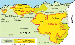
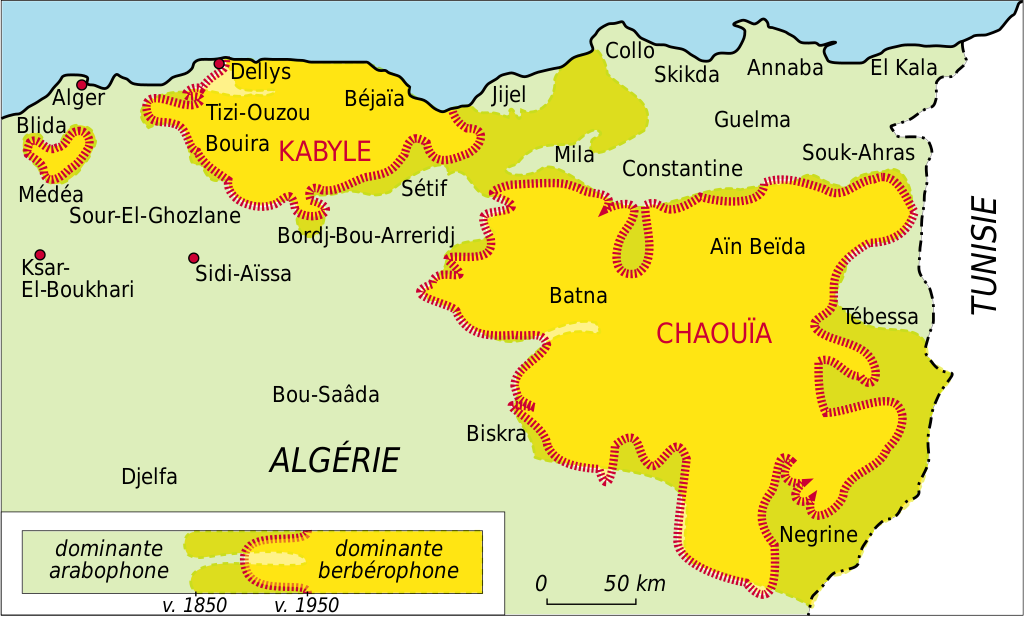
English: French map of linguistic areas in North-Eastern Algeria.
Français : Carte en français des aires linguistiques du nord-est algérien. |
| Date | 02/03/2009 |
| Source |
Own work Sources :
|
| Author | Fanfwah |
| Other versions |
 |
| Camera location | | View this and other nearby images on: OpenStreetMap |
|---|
Licensing
I, the copyright holder of this work, hereby publish it under the following licenses:

|
Permission is granted to copy, distribute and/or modify this document under the terms of the GNU Free Documentation License, Version 1.2 or any later version published by the Free Software Foundation; with no Invariant Sections, no Front-Cover Texts, and no Back-Cover Texts. A copy of the license is included in the section entitled GNU Free Documentation License. |
This file is licensed under the Creative Commons Attribution-Share Alike 3.0 Unported, 2.5 Generic, 2.0 Generic and 1.0 Generic license.
- You are free:
- to share – to copy, distribute and transmit the work
- to remix – to adapt the work
- Under the following conditions:
- attribution – You must give appropriate credit, provide a link to the license, and indicate if changes were made. You may do so in any reasonable manner, but not in any way that suggests the licensor endorses you or your use.
- share alike – If you remix, transform, or build upon the material, you must distribute your contributions under the same or compatible license as the original.
You may select the license of your choice.
File history
Click on a date/time to view the file as it appeared at that time.
| Date/Time | Thumbnail | Dimensions | User | Comment | |
|---|---|---|---|---|---|
| current | 06:04, 27 March 2009 | | 1,461 × 881 (114 KB) | Fanfwah | Simplification du tracé de la légende. Amélioration du contraste XIXe-XXe. |
| 22:55, 12 March 2009 |  | 1,461 × 881 (114 KB) | Fanfwah | Modification du texte de la légende : "dominante" arabophone/berbérophone. Pointillé sur les tracés du XIXe. | |
| 05:47, 11 March 2009 |  | 1,461 × 881 (114 KB) | Fanfwah | Police "Deja Vu" | |
| 04:05, 8 March 2009 |  | 1,461 × 881 (111 KB) | Fanfwah | Ajustements tracés + présentation en pointillé | |
| 07:59, 7 March 2009 |  | 1,461 × 881 (113 KB) | Fanfwah | Dates plus précises. Ajustement du tracé du XIXe siècle vers la côte. Simplification des tracés et des couleurs. | |
| 03:02, 2 March 2009 |  | 1,461 × 881 (149 KB) | Fanfwah | rectification position textes | |
| 02:33, 2 March 2009 |  | 1,461 × 881 (148 KB) | Fanfwah | {{Information |Description={{en|1=French map of linguistic areas in North-Eastern Algeria.}} {{fr|1=Carte en français des aires linguistiques du nord-est algérien.}} |Source=Travail personnel (own work). Sources : Salem Chaker, ''Textes en Linguistique |
File usage
The following page uses this file:
Global file usage
The following other wikis use this file:
- Usage on af.wikipedia.org
- Usage on ca.wikipedia.org
- Usage on da.wikipedia.org
- Usage on de.wikipedia.org
- Usage on en.wikipedia.org
- Usage on eo.wikipedia.org
- Usage on es.wikipedia.org
- Usage on fa.wikipedia.org
- Usage on fr.wikipedia.org
- Usage on fy.wikipedia.org
- Usage on gl.wikipedia.org
- Usage on incubator.wikimedia.org
- Usage on ja.wikipedia.org
- Usage on kab.wikipedia.org
- Usage on lad.wikipedia.org
- Usage on my.wikipedia.org
- Usage on nl.wikipedia.org
- Usage on nn.wikipedia.org
- Usage on no.wikipedia.org
- Usage on ru.wikipedia.org
- Usage on sr.wikipedia.org