
File:Caucasus 300 map alt de.png
Size of this preview: 771 × 599 pixels. Other resolutions: 309 × 240 pixels | 618 × 480 pixels | 988 × 768 pixels | 1,280 × 995 pixels | 2,560 × 1,990 pixels | 2,990 × 2,324 pixels.
Original file (2,990 × 2,324 pixels, file size: 3.02 MB, MIME type: image/png)
| This is a file from the Wikimedia Commons. Information from its description page there is shown below. Commons is a freely licensed media file repository. You can help. |
Summary
| Description |
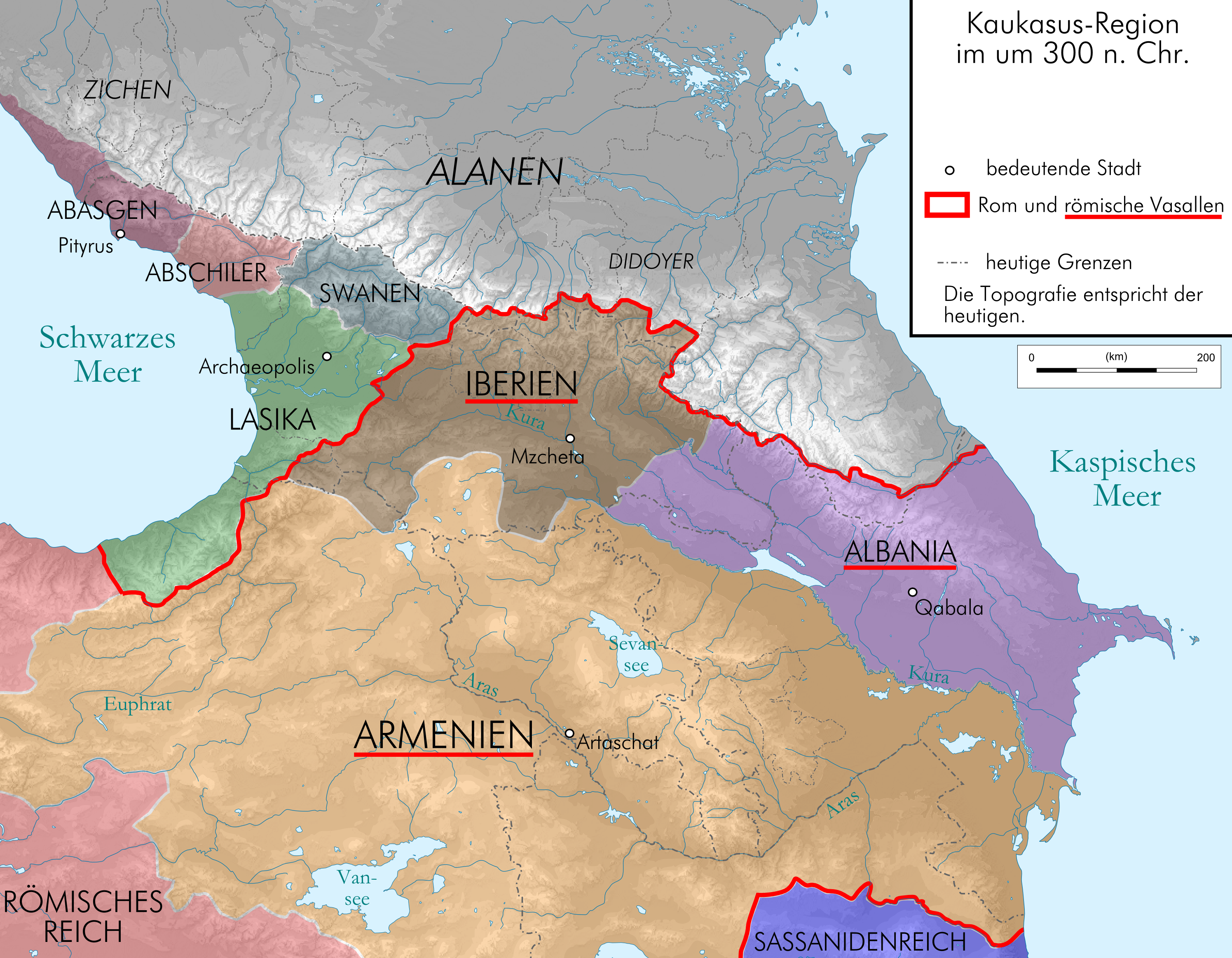
English: Map of Caucasus around 300 AC in German.
Deutsch: Kaukasus-Region um 300 n. Chr. Quellen sind File:Geor_earliest_2A.jpg , Putzger historischer Weltatlas Ausgabe 2005, Heinz Fähnrich: Geschichte Georgiens von den Anfängen bis zur Mongolenherrschaft. Shaker, Aachen 1993, ISBN 3-86111-683-9., http://www.armenica.org/cgi-bin/armenica.cgi?178711717323498=1=3==Armenia==1=3=AAA |
| Date | |
| Source | work by uploader, derivate of File:Caucasus_topographic_map-fr.svg |
| Author | Don-kun |
| Other versions |
 |
Licensing
I, the copyright holder of this work, hereby publish it under the following licenses:
This file is licensed under the Creative Commons Attribution-Share Alike 3.0 Unported license.
- You are free:
- to share – to copy, distribute and transmit the work
- to remix – to adapt the work
- Under the following conditions:
- attribution – You must give appropriate credit, provide a link to the license, and indicate if changes were made. You may do so in any reasonable manner, but not in any way that suggests the licensor endorses you or your use.
- share alike – If you remix, transform, or build upon the material, you must distribute your contributions under the same or compatible license as the original.

|
Permission is granted to copy, distribute and/or modify this document under the terms of the GNU Free Documentation License, Version 1.2 or any later version published by the Free Software Foundation; with no Invariant Sections, no Front-Cover Texts, and no Back-Cover Texts. A copy of the license is included in the section entitled GNU Free Documentation License. |
You may select the license of your choice.
File history
Click on a date/time to view the file as it appeared at that time.
| Date/Time | Thumbnail | Dimensions | User | Comment | |
|---|---|---|---|---|---|
| current | 08:06, 24 September 2015 | | 2,990 × 2,324 (3.02 MB) | RokerHRO | optipng -o7 -i0 -zc1-9 -zm1-9 -zs0-3 -f0-5 → 13.51% decrease |
| 19:56, 17 August 2009 |  | 2,990 × 2,324 (3.49 MB) | Don-kun | following Fähnrich, Iberia lost southern territories at the end of the rule of Amasasp III (260-265) | |
| 22:04, 8 August 2009 |  | 2,990 × 2,324 (3.48 MB) | Don-kun | {{Information |Description={{en|1=Map of Caucasus around 300 AC in German.}} {{de|1=Kaukasus-Region um 300 n. Chr. Quellen sind http://commons.wikimedia.org/wiki/File:Geor_earliest_2A.jpg , Putzger historischer Weltatlas Ausgabe 2005, Heinz Fähnrich: Ges |
File usage
The following page uses this file:
Global file usage
The following other wikis use this file:
- Usage on azb.wikipedia.org
- Usage on ca.wikipedia.org
- Usage on cs.wikipedia.org
- Usage on cv.wikipedia.org
- Usage on de.wikipedia.org
- Usage on el.wikipedia.org
- Usage on en.wikipedia.org
- Usage on eo.wikipedia.org
- Usage on eu.wikipedia.org
- Usage on fr.wikipedia.org
- Usage on hr.wikipedia.org
- Usage on hy.wikipedia.org
- Usage on hyw.wikipedia.org
- Usage on it.wikipedia.org
- Usage on ka.wikipedia.org
- Usage on ko.wikipedia.org
- Usage on nl.wikipedia.org
- Usage on pt.wikipedia.org
- Usage on sl.wikipedia.org
- Usage on sr.wikipedia.org
- Usage on uk.wikipedia.org
- Usage on vi.wikipedia.org
- Usage on zh.wikipedia.org