
File:Map of the Viceroyalty of Peru.svg

Size of this PNG preview of this SVG file: 800 × 407 pixels. Other resolutions: 320 × 163 pixels | 640 × 325 pixels | 1,024 × 520 pixels | 1,280 × 650 pixels | 2,560 × 1,301 pixels | 3,121 × 1,586 pixels.
Original file (SVG file, nominally 3,121 × 1,586 pixels, file size: 1.67 MB)
| This is a file from the Wikimedia Commons. Information from its description page there is shown below. Commons is a freely licensed media file repository. You can help. |
Summary
| Description |
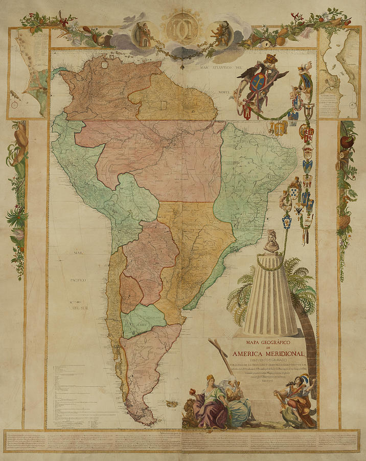
Español: Mapa de ubicación del Virreinato del Perú (territorio inicial (1542) y final (1810) de iure) English: Locator map of the Viceroyalty of Peru (initial (1542) and final (1810) de jure territory). |
| Date | (UTC) |
| Source |
|
| Author | Shadowxfox |
.jpg)
Licensing
This file is licensed under the Creative Commons Attribution-Share Alike 3.0 Unported license.
- You are free:
- to share – to copy, distribute and transmit the work
- to remix – to adapt the work
- Under the following conditions:
- attribution – You must give appropriate credit, provide a link to the license, and indicate if changes were made. You may do so in any reasonable manner, but not in any way that suggests the licensor endorses you or your use.
- share alike – If you remix, transform, or build upon the material, you must distribute your contributions under the same or compatible license as the original.
File history
Click on a date/time to view the file as it appeared at that time.
| Date/Time | Thumbnail | Dimensions | User | Comment | |
|---|---|---|---|---|---|
| current | 16:47, 22 January 2024 | | 3,121 × 1,586 (1.67 MB) | Janitoalevic | Reverted to version as of 16:41, 18 January 2024 (UTC) En el mapa se muestran territorios de iure, la Amazonía por ejemplo, no se ocupó de facto, mismo caso con la Patagonia. |
| 19:41, 20 January 2024 |  | 3,121 × 1,586 (1.67 MB) | ULIFOX 3XX | Reverted to version as of 04:37, 5 January 2024 (UTC) Si no fue 'De facto' parte del territorio de la Capitanía General de Chile, porque en la practica no fue parte del Virreinato | |
| 16:41, 18 January 2024 |  | 3,121 × 1,586 (1.67 MB) | Janitoalevic | Reverted to version as of 01:41, 16 August 2023 (UTC) La Patagonia pertenecía de iure a a Chile y por ende virreinato del Perú. También los territorios de la Amazonía se encontraban bajo dominio de iure. | |
| 04:37, 5 January 2024 |  | 3,121 × 1,586 (1.67 MB) | ULIFOX 3XX | El Virreinato del Perú nunca tuvo la patagonia como territorio inicial. La Patagonia fue adquirida por Chile y Argentina (ya independizados) despues de 1880 | |
| 01:41, 16 August 2023 |  | 3,121 × 1,586 (1.67 MB) | Janitoalevic | En verde claro van los territorios que dejaron de ser del virreinato del Perú con las reformas borbónicas. | |
| 09:24, 4 May 2023 |  | 3,121 × 1,586 (1.67 MB) | Durero | Los territorios que el virreinato nunca controló de forma efectivo van en verde claro | |
| 16:04, 14 February 2023 |  | 3,121 × 1,586 (1.67 MB) | Janitoalevic | Reverted to version as of 03:20, 29 December 2022 (UTC) | |
| 16:08, 19 January 2023 |  | 3,121 × 1,586 (1.67 MB) | Durero | Reverted to version as of 21:41, 12 December 2022 (UTC) | |
| 03:20, 29 December 2022 |  | 3,121 × 1,586 (1.67 MB) | Janitoalevic | Fuente: 1 2 [https://es.wikipedia.org/wiki/Fronteras_de_Chile#cite_note-HistoriaDeLasFronteras-13] | |
| 21:41, 12 December 2022 |  | 3,121 × 1,586 (1.67 MB) | Echando una mano | Reverted to version as of 12:20, 7 September 2022 (UTC): no se corresponde con la realidad. |
.jpg)
File usage
The following page uses this file:
Global file usage
The following other wikis use this file:
- Usage on ar.wikipedia.org
- Usage on ast.wikipedia.org
- Usage on be.wikipedia.org
- Usage on bg.wikipedia.org
- Usage on ca.wikipedia.org
- Usage on cs.wikipedia.org
- Usage on cy.wikipedia.org
- Usage on da.wikipedia.org
- Usage on en.wikipedia.org
- Usage on es.wikipedia.org
- Historia universal
- Virreinato del Perú
- Imperio español
- Conquista del Imperio incaico
- Hipólito Francisco de Villegas
- Tacna, Arica y Tarapacá hasta 1929
- Organización territorial del virreinato del Perú
- Pedro Álvarez Holguín
- Miguel Mariano de Villegas
- Juan de Lacoizqueta
- Manuel Maciel y Cabral de Alpoin
- Usage on et.wikipedia.org
- Usage on eu.wikipedia.org
- Usage on fa.wikipedia.org
- Usage on fr.wikipedia.org
- Usage on he.wikipedia.org
- Usage on ia.wikipedia.org
- Usage on id.wikipedia.org
- Usage on it.wikipedia.org
- Usage on ja.wikipedia.org
- Usage on ka.wikipedia.org
- Usage on ko.wikipedia.org
- Usage on la.wikipedia.org
- Usage on lt.wikipedia.org
- Usage on mk.wikipedia.org
- Usage on mt.wikipedia.org
- Usage on nl.wikipedia.org
- Usage on no.wikipedia.org
- Usage on pl.wikipedia.org
- Usage on pt.wikipedia.org
- Usage on qu.wikipedia.org
- Usage on ro.wikipedia.org
- Usage on ru.wikipedia.org
- Usage on sk.wikipedia.org
- Usage on sr.wikipedia.org
View more global usage of this file.