
File:Deutschland Besatzungszonen 1945 1946.png
Size of this preview: 464 × 599 pixels. Other resolutions: 186 × 240 pixels | 500 × 646 pixels.
Original file (500 × 646 pixels, file size: 20 KB, MIME type: image/png)
| This is a file from the Wikimedia Commons. Information from its description page there is shown below. Commons is a freely licensed media file repository. You can help. |
Summary

|
File:Deutschland Besatzungszonen 8 Jun 1947 - 22 Apr 1949.svg is a vector version of this file. It should be used in place of this PNG file.
File:Deutschland Besatzungszonen 1945 1946.png → File:Deutschland Besatzungszonen 8 Jun 1947 - 22 Apr 1949.svg
For more information, see Help:SVG. |
 |
Description, source and licence
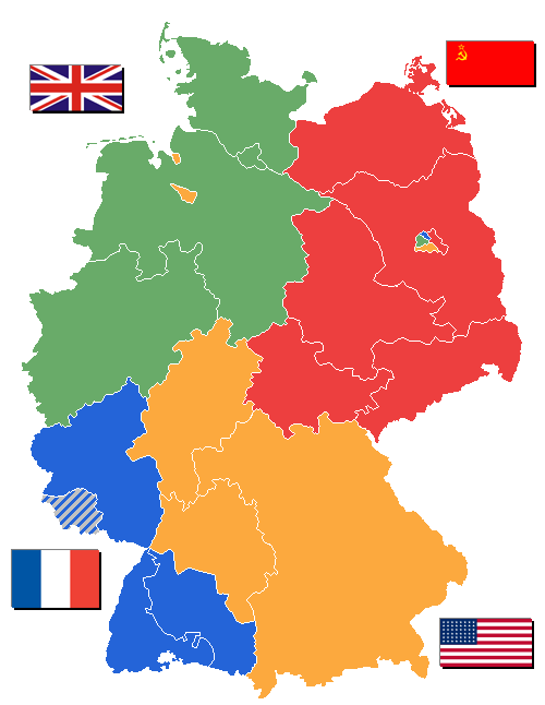
Some states of Germany ("Bundesländer" or initially "Länder") weren't created until 1946 - others Saarland, however, was removed from the French zone of occupation in 1946. State borders as shown are correct after Lippe became part of Northrhine-Westphalia January, 21st 1947.
Flags taken from Wikipedia.
Map drawn by user WikiNight
Nederlands: Geallieerde bezettingszones in Duitsland 1945/1946 met deelstaten
Licensing

|
Permission is granted to copy, distribute and/or modify this document under the terms of the GNU Free Documentation License, Version 1.2 or any later version published by the Free Software Foundation; with no Invariant Sections, no Front-Cover Texts, and no Back-Cover Texts. A copy of the license is included in the section entitled GNU Free Documentation License. |
| This file is licensed under the Creative Commons Attribution-Share Alike 3.0 Unported license. | ||
| ||
| This licensing tag was added to this file as part of the GFDL licensing update. |
Image History
- 11:44, 31. Okt 2005 . . WikiNight (Diskussion) . . 500 x 646 (26694 Byte) (+Landkreis Lindau korr.)
- 13:27, 20. Sep 2005 . . WikiNight (Diskussion) . . 500 x 646 (26738 Byte) (Manche Bundesländer sind erst 1946 gebildet worden. 1946 aber auch das Saarland aus der fr.BZ rausgenommen. Bild selbst erstellt.)
derivative works
Derivative works of this file: Germany Occupation Zones 1947 blank.jpg
File history
Click on a date/time to view the file as it appeared at that time.
| Date/Time | Thumbnail | Dimensions | User | Comment | |
|---|---|---|---|---|---|
| current | 13:03, 2 September 2006 | | 500 × 646 (20 KB) | Wereon | In 1945-46, US flag had 48 stars |
| 10:13, 1 January 2006 |  | 500 × 646 (26 KB) | W-j-s | == Beschreibung, Quelle und Lizenz == Manche Bundesländer sind erst 1946 gebildet worden. 1946 aber auch das Saarland aus der fr.BZ rausgenommen. Flaggen aus Wikipedia<br/> Karte gezeichnet von User DE:WikiNight Versionsgeschichte siehe http://de.wiki |
File usage
There are no pages that use this file.
Global file usage
The following other wikis use this file:
- Usage on als.wikipedia.org
- Usage on an.wikipedia.org
- Usage on az.wikipedia.org
- Usage on bg.wikipedia.org
- Usage on br.wikipedia.org
- Usage on ca.wikipedia.org
- Usage on de.wikipedia.org
- Usage on en.wikipedia.org
- Usage on eu.wikipedia.org
- Usage on fr.wikipedia.org
- Usage on gl.wikipedia.org
- Usage on hr.wikipedia.org
- Usage on hu.wikipedia.org
- Usage on it.wikipedia.org
- Usage on lij.wikipedia.org
- Usage on mwl.wikipedia.org
- Usage on no.wikipedia.org
- Usage on pl.wikipedia.org
- Usage on ro.wikipedia.org
- Usage on sl.wikipedia.org
- Usage on sq.wikipedia.org
- Usage on sw.wikipedia.org
- Usage on tr.wikipedia.org
- Usage on vec.wikipedia.org