
File:Electoral College 2012.svg

Size of this PNG preview of this SVG file: 800 × 465 pixels. Other resolutions: 320 × 186 pixels | 640 × 372 pixels | 1,024 × 595 pixels | 1,280 × 744 pixels | 2,560 × 1,488 pixels | 1,020 × 593 pixels.
Original file (SVG file, nominally 1,020 × 593 pixels, file size: 35 KB)
| This is a file from the Wikimedia Commons. Information from its description page there is shown below. Commons is a freely licensed media file repository. You can help. |
| Description |
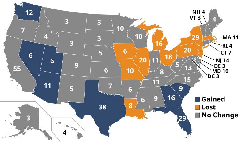
English: خارطة المجمع الانتخابي الخاص بِانتخابات الرئاسة الأمريكيَّة لِسنة 2012. 2016 and 2020 United States presidential elections, using apportionment data released by the US Census Bureau. |
||||||||
| Date | |||||||||
| Source | http://2010.census.gov/news/img/apport_chart4_appttot.jpg, modified by uploader | ||||||||
| Author | United States Census 2010, modified by Adam Lenhardt | ||||||||
| Permission (Reusing this file) |
|
||||||||
| Other versions |
|
||||||||
| SVG development | This map was created with an unknown SVG tool. |
||||||||


File history
Click on a date/time to view the file as it appeared at that time.
| Date/Time | Thumbnail | Dimensions | User | Comment | |
|---|---|---|---|---|---|
| current | 15:12, 18 January 2017 | | 1,020 × 593 (35 KB) | Newfraferz87 | Clearer state borders |
| 11:23, 27 July 2016 |  | 1,020 × 593 (35 KB) | Newfraferz87 | Group fonts | |
| 14:18, 20 July 2016 |  | 1,020 × 593 (36 KB) | Newfraferz87 | Shrink code | |
| 18:10, 21 December 2010 |  | 1,020 × 593 (118 KB) | Cg-realms | Readjusted key to fit better. | |
| 17:59, 21 December 2010 |  | 1,020 × 593 (118 KB) | Cg-realms | {{Information |Description={{en|1=Electoral college map for the 2012 and 2016 United States presidential elections, using a |
File usage
The following page uses this file:
Global file usage
The following other wikis use this file:
- Usage on ar.wikipedia.org
- Usage on bcl.wikipedia.org
- Usage on bg.wikipedia.org
- Usage on ca.wikipedia.org
- Usage on cs.wikipedia.org
- Usage on de.wikipedia.org
- Usage on el.wikipedia.org
- Usage on en.wikipedia.org
- Usage on es.wikipedia.org
- Usage on fa.wikipedia.org
- Usage on fi.wikipedia.org
- Usage on frr.wikipedia.org
- Usage on fy.wikipedia.org
- Usage on he.wikipedia.org
- Usage on id.wikipedia.org
- Usage on ko.wikipedia.org
- Usage on nl.wikipedia.org
- Usage on no.wikipedia.org
- Usage on pt.wikipedia.org
- Usage on ro.wikipedia.org
- Usage on ru.wikipedia.org
- Usage on sh.wikipedia.org
- Usage on si.wikipedia.org
- Usage on sr.wikipedia.org
- Usage on sv.wikipedia.org
- Usage on tr.wikipedia.org
- Usage on vi.wikipedia.org
- Usage on zh.wikipedia.org