
File:Electoral College 2016.svg

Size of this PNG preview of this SVG file: 800 × 465 pixels. Other resolutions: 320 × 186 pixels | 640 × 372 pixels | 1,024 × 595 pixels | 1,280 × 744 pixels | 2,560 × 1,488 pixels | 1,020 × 593 pixels.
Original file (SVG file, nominally 1,020 × 593 pixels, file size: 28 KB)
| This is a file from the Wikimedia Commons. Information from its description page there is shown below. Commons is a freely licensed media file repository. You can help. |
Summary
| Description |
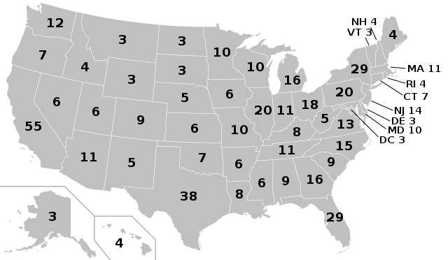
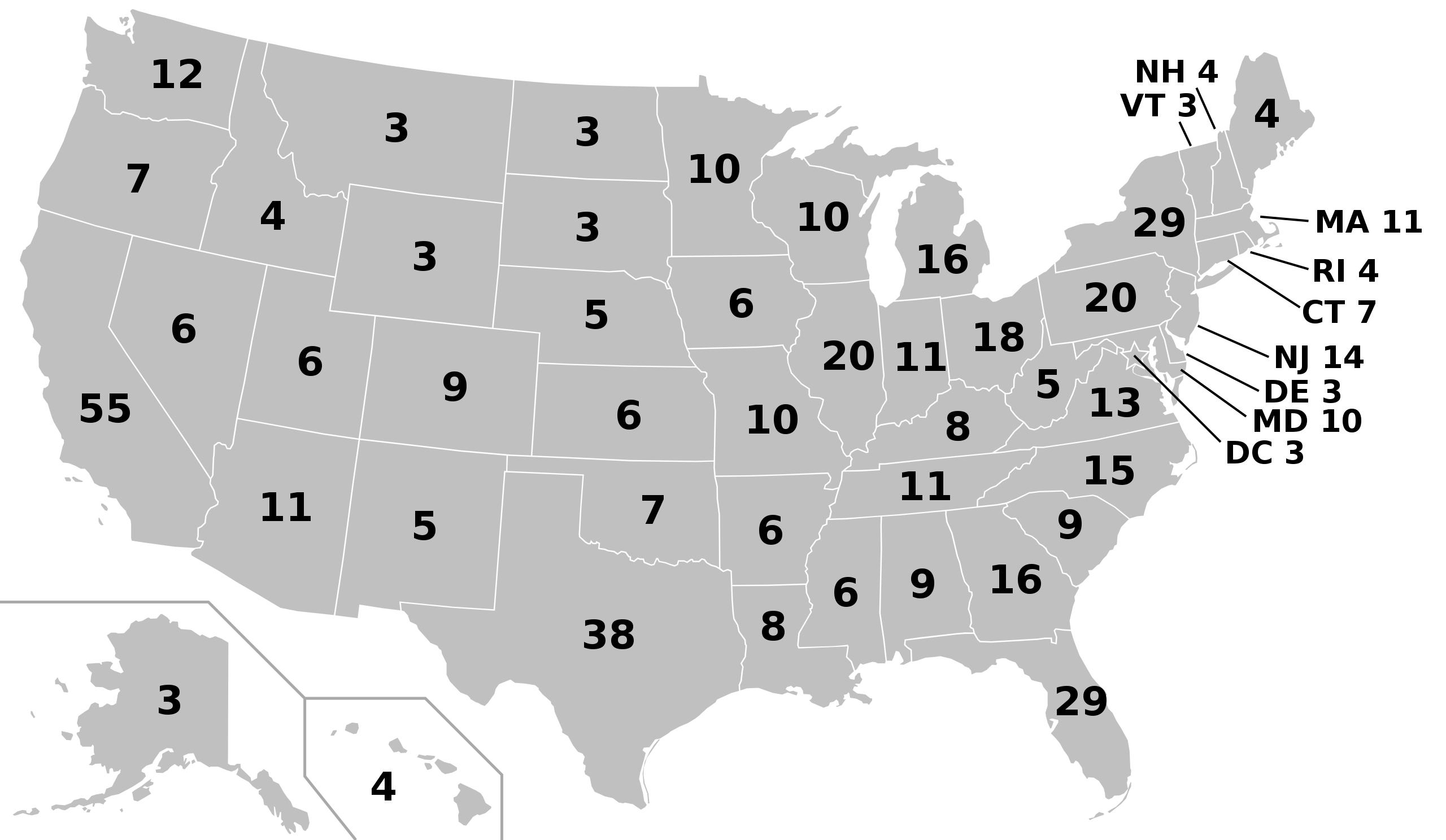
English: Electoral college map for the 2012, 2016 and 2020 United States presidential elections, using apportionment data released by the US Census Bureau. This case only shows the electoral votes. Please update real-time results here. Español: Mapa del colegio electoral para las elecciones presidenciales de Estados Unidos de 2012, 2016 y 2020, a partir de datos prorrateados dadas a conocer por la Oficina de Censos de Estados Unidos |
| Date | |
| Source | USCB |
| Author |
Original: Cg-realms Derivative work: Ali Zifan |
| SVG development | This map was created with an unknown SVG tool. |
Licensing
This work is in the public domain in the United States because it is a work prepared by an officer or employee of the United States Government as part of that person’s official duties under the terms of Title 17, Chapter 1, Section 105 of the US Code.
Note: This only applies to original works of the Federal Government and not to the work of any individual U.S. state, territory, commonwealth, county, municipality, or any other subdivision. This template also does not apply to postage stamp designs published by the United States Postal Service since 1978. (See § 313.6(C)(1) of Compendium of U.S. Copyright Office Practices). It also does not apply to certain US coins; see The US Mint Terms of Use.
|
 | |
| This file has been identified as being free of known restrictions under copyright law, including all related and neighboring rights. | ||
| I, the copyright holder of this work, release this work into the public domain. This applies worldwide. In some countries this may not be legally possible; if so: I grant anyone the right to use this work for any purpose, without any conditions, unless such conditions are required by law. |
File history
Click on a date/time to view the file as it appeared at that time.
| Date/Time | Thumbnail | Dimensions | User | Comment | |
|---|---|---|---|---|---|
| current | 13:04, 24 November 2018 | | 1,020 × 593 (28 KB) | Newfraferz87 | Using this but without labels |
| 14:39, 18 January 2017 |  | 1,020 × 593 (34 KB) | Newfraferz87 | Clearer state borders | |
| 05:00, 3 November 2016 |  | 1,020 × 593 (35 KB) | Newfraferz87 | Preempt: temporary file, prevent this file from being updated for election results (results should use this one | |
| 13:38, 22 July 2016 |  | 1,020 × 593 (35 KB) | Newfraferz87 | Remove erroneous "line-height" attribute | |
| 09:32, 12 July 2016 |  | 1,020 × 593 (35 KB) | Newfraferz87 | Backward derivation from result map | |
| 05:44, 10 April 2016 |  | 1,020 × 593 (70 KB) | Oganesson007 | default colors, reduced size | |
| 05:41, 10 April 2016 |  | 1,020 × 593 (109 KB) | Oganesson007 | no yet!.. | |
| 05:41, 10 April 2016 |  | 1,020 × 593 (70 KB) | Oganesson007 | default colors | |
| 22:57, 14 March 2013 |  | 1,020 × 593 (109 KB) | EmmaCoop | User created page with UploadWizard |
File usage
There are no pages that use this file.
Global file usage
The following other wikis use this file:
- Usage on en.wikipedia.org
- Usage on fa.wikipedia.org
- Usage on fr.wikipedia.org
- Usage on hu.wikipedia.org
- Usage on ja.wikipedia.org