
File:European Middle Neolithic.gif
Size of this preview: 800 × 397 pixels. Other resolutions: 320 × 159 pixels | 640 × 317 pixels | 1,307 × 648 pixels.
Original file (1,307 × 648 pixels, file size: 101 KB, MIME type: image/gif)
| This is a file from the Wikimedia Commons. Information from its description page there is shown below. Commons is a freely licensed media file repository. You can help. |
Summary

|
File:European-middle-neolithic-en.svg is a vector version of this file. It should be used in place of this GIF file when not inferior.
File:European Middle Neolithic.gif → File:European-middle-neolithic-en.svg
For more information, see Help:SVG. |
 |
.
| Description |
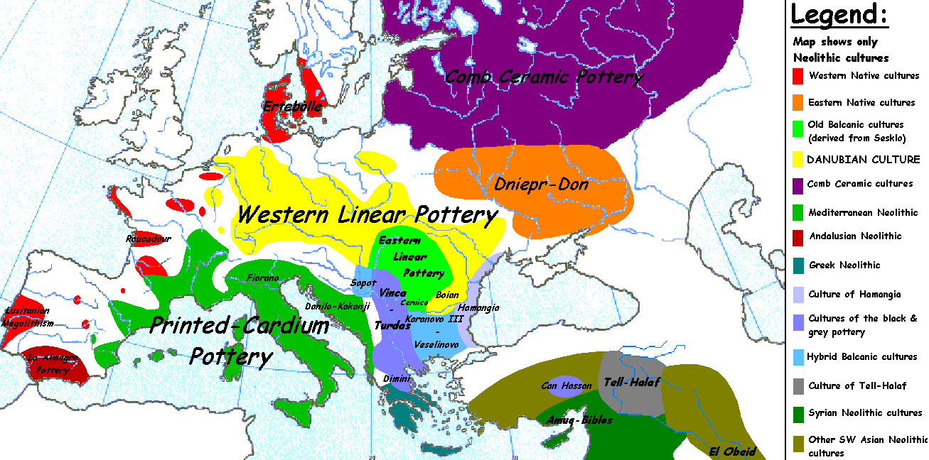
English: Map of the second half European Middle Neolithic at the apogee of Danubian and Mediterranean expansion. (The modification of the original map - Combed pottery, earlier notated as Pitted Ware, see history without respecting the color code of the legend is something that I am not fully satisfied with). |
| Date | 5 April 2005 (original upload date) |
| Source | Transferred from en.wikipedia to Commons. |
| Author | Later versions were uploaded by Clarifer at en.wikipedia. |
| Other versions |
[]
|


_en.png)
.png)
.jpg)
Licensing
| This work has been released into the public domain by its author, Sugaar at English Wikipedia. This applies worldwide. In some countries this may not be legally possible; if so: Sugaar grants anyone the right to use this work for any purpose, without any conditions, unless such conditions are required by law. |
Original upload log
The original description page was here. All following user names refer to en.wikipedia.
- 2005-08-28 13:11 Clarifer 1320×663×8 (106148 bytes) Added the approximate area of the Comb Ceramic culture. Source: National Board of Antiquities, Finland. www.nba.fi
- 2005-04-05 20:12 Sugaar 1320×663×8 (103228 bytes) Map of the second half European Middle Neolithic at the apogee of Danubian and Mediterranean expansion (c. 4500-4000 BCE). Made by [[Sugaar]]. Free use authorized by the author.
File history
Click on a date/time to view the file as it appeared at that time.
| Date/Time | Thumbnail | Dimensions | User | Comment | |
|---|---|---|---|---|---|
| current | 06:43, 18 April 2014 | | 1,307 × 648 (101 KB) | Spiridon Ion Cepleanu | Neolithic shorelines and banks, little details |
| 00:39, 22 March 2010 |  | 1,307 × 648 (101 KB) | Ras67 | cropped | |
| 00:50, 14 February 2007 |  | 1,320 × 663 (104 KB) | 32X | Auf eine alte Version zurückgesetzt | |
| 00:49, 14 February 2007 |  | 1,320 × 663 (101 KB) | 32X | Original version by Sugaar. | |
| 11:14, 31 December 2005 |  | 1,320 × 663 (104 KB) | Glenn | Originally uploaded to en-wiki: Quote: "Map of the second half European Middle Neolithic at the apogee of Danubian and Mediterranean expansion (c. 4500-4000 BCE)." Upload text: "20:12, 5 April 2005 . . Sugaar . . 1320x663 (103228 bytes) (Map of the secon |
File usage
The following 2 pages use this file:
Global file usage
The following other wikis use this file:
- Usage on az.wikipedia.org
- Usage on be.wikipedia.org
- Usage on bg.wikipedia.org
- Usage on bs.wikipedia.org
- Usage on ca.wikipedia.org
- Usage on cs.wikipedia.org
- Usage on da.wikipedia.org
- Usage on da.wikibooks.org
- Usage on de.wikipedia.org
- Usage on en.wikipedia.org
- Usage on et.wikipedia.org
- Usage on fi.wikipedia.org
- Usage on fi.wikibooks.org
- Usage on gl.wikipedia.org
- Usage on he.wikipedia.org
- Usage on hi.wikipedia.org
- Usage on hr.wikipedia.org
- Usage on hu.wikipedia.org
- Usage on it.wikipedia.org
View more global usage of this file.