
File:Kingman Reef.png

Size of this preview: 597 × 600 pixels. Other resolutions: 239 × 240 pixels | 631 × 634 pixels.
Original file (631 × 634 pixels, file size: 431 KB, MIME type: image/png)
| This is a file from the Wikimedia Commons. Information from its description page there is shown below. Commons is a freely licensed media file repository. You can help. |
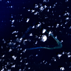
Kingman Reef - NASA NLT Landsat 7 (Visible Color) Satellite Image
Español: Arrecife Kingman, situado al norte del océano Pacífico, aproximadamente a medio camino entre Hawaii y Samoa Americana. Imagen por satélite NASA NLT Landsat 7 (Espectro visible).
| This file is in the public domain in the United States because it was solely created by NASA. NASA copyright policy states that "NASA material is not protected by copyright unless noted". (See Template:PD-USGov, NASA copyright policy page or JPL Image Use Policy.) | ||
 |
Warnings:
|
File history
Click on a date/time to view the file as it appeared at that time.
| Date/Time | Thumbnail | Dimensions | User | Comment | |
|---|---|---|---|---|---|
| current | 14:06, 10 April 2005 | | 631 × 634 (431 KB) | Bollar | Kingman Reef Satellite Picture (NLT Landsat 7 Visible Color) {{PD-USGov-NASA}} |
File usage
The following page uses this file:
Global file usage
The following other wikis use this file:
- Usage on af.wikipedia.org
- Usage on bs.wikipedia.org
- Usage on ca.wikipedia.org
- Usage on cs.wikipedia.org
- Usage on de.wikipedia.org
- Usage on el.wikipedia.org
- Usage on eo.wikipedia.org
- Usage on frr.wikipedia.org
- Usage on gl.wikipedia.org
- Usage on he.wikipedia.org
- Usage on hr.wikipedia.org
- Usage on id.wikipedia.org
- Usage on is.wikipedia.org
- Usage on mk.wikipedia.org
- Usage on ml.wikipedia.org
- Usage on ms.wikipedia.org
- Usage on nl.wikipedia.org
- Usage on pt.wikipedia.org
- Usage on sh.wikipedia.org
- Usage on sr.wikipedia.org
- Usage on su.wikipedia.org
- Usage on vi.wikipedia.org