
File:LAR ga map.png
Size of this preview: 800 × 309 pixels. Other resolutions: 320 × 124 pixels | 640 × 247 pixels | 1,024 × 396 pixels | 2,200 × 850 pixels.
Original file (2,200 × 850 pixels, file size: 904 KB, MIME type: image/png)
| This is a file from the Wikimedia Commons. Information from its description page there is shown below. Commons is a freely licensed media file repository. You can help. |
Summary
| Description |
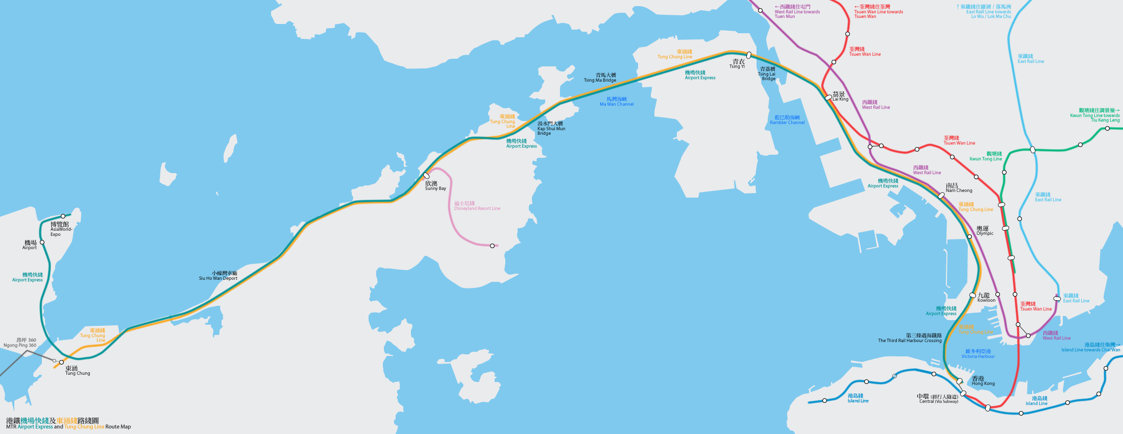
港鐵機場快綫及東涌綫路線圖(按真實地形繪畫) Geographically accurate map of the MTR Airport Express and Tung Chung Line By Bus_28a, Mtrkwt |
| Date | 25 February 2006 (original upload date) |
| Source | No machine-readable source provided. Own work assumed (based on copyright claims). |
| Author | No machine-readable author provided. Mtrkwt assumed (based on copyright claims). |
Licensing
I, the copyright holder of this work, hereby publish it under the following licenses:

|
Permission is granted to copy, distribute and/or modify this document under the terms of the GNU Free Documentation License, Version 1.2 or any later version published by the Free Software Foundation; with no Invariant Sections, no Front-Cover Texts, and no Back-Cover Texts. A copy of the license is included in the section entitled GNU Free Documentation License. |
| This file is licensed under the Creative Commons Attribution-Share Alike 3.0 Unported license. | ||
| ||
| This licensing tag was added to this file as part of the GFDL licensing update. |
This file is licensed under the Creative Commons Attribution-Share Alike 2.5 Generic, 2.0 Generic and 1.0 Generic license.
- You are free:
- to share – to copy, distribute and transmit the work
- to remix – to adapt the work
- Under the following conditions:
- attribution – You must give appropriate credit, provide a link to the license, and indicate if changes were made. You may do so in any reasonable manner, but not in any way that suggests the licensor endorses you or your use.
- share alike – If you remix, transform, or build upon the material, you must distribute your contributions under the same or compatible license as the original.
You may select the license of your choice.

|
This map image could be re-created using vector graphics as an SVG file. This has several advantages; see Commons:Media for cleanup for more information. If an SVG form of this image is available, please upload it and afterwards replace this template with
{{vector version available|new image name}}.
It is recommended to name the SVG file “LAR ga map.svg”—then the template Vector version available (or Vva) does not need the new image name parameter. |
File history
Click on a date/time to view the file as it appeared at that time.
| Date/Time | Thumbnail | Dimensions | User | Comment | |
|---|---|---|---|---|---|
| current | 16:22, 28 December 2014 | 2,200 × 850 (904 KB) | Mtrkwt | Update for ISL | |
| 08:16, 16 August 2009 | 2,200 × 850 (676 KB) | Mtrkwt | Update for KSL. | ||
| 13:01, 22 February 2009 | 2,200 × 850 (313 KB) | Hokachung | Ngong Ping 360 | ||
| 08:25, 3 December 2007 | 2,200 × 850 (658 KB) | Mtrkwt | |||
| 06:42, 28 January 2007 | 2,200 × 850 (500 KB) | Mtrkwt | |||
| 10:07, 26 February 2006 | 2,200 × 850 (496 KB) | Mtrkwt | Geographically accurate map of the MTR Airport Express and Tung Chung Line | ||
| 19:44, 25 February 2006 | 2,200 × 850 (492 KB) | Mtrkwt | 地鐵機場快綫及東涌綫路線圖路線圖(按真實地形繪畫) | ||
| 19:34, 25 February 2006 | 2,200 × 850 (493 KB) | Mtrkwt | 地鐵機場快綫及東涌綫路線圖(按真實地形繪畫) |
File usage
The following page uses this file:
Global file usage
The following other wikis use this file:
- Usage on de.wikipedia.org
- Usage on fi.wikipedia.org
- Usage on fr.wikipedia.org
- Usage on ja.wikipedia.org
- Usage on nl.wikipedia.org
- Usage on pl.wikipedia.org
- Usage on ru.wikipedia.org
- Usage on sk.wikipedia.org
- Usage on th.wikipedia.org
- Usage on www.wikidata.org
- Usage on zh-min-nan.wikipedia.org
- Usage on zh-yue.wikipedia.org