
File:Ladakh locator map.svg

Size of this PNG preview of this SVG file: 764 × 600 pixels. Other resolutions: 306 × 240 pixels | 611 × 480 pixels | 978 × 768 pixels | 1,280 × 1,005 pixels | 2,560 × 2,010 pixels | 2,160 × 1,696 pixels.
Original file (SVG file, nominally 2,160 × 1,696 pixels, file size: 202 KB)
| This is a file from the Wikimedia Commons. Information from its description page there is shown below. Commons is a freely licensed media file repository. You can help. |
| Title |
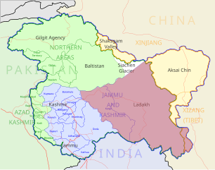
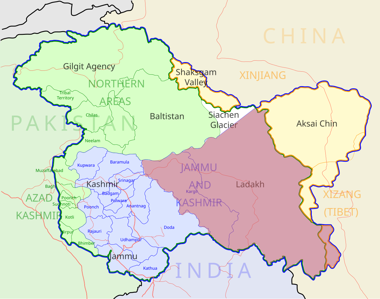
Ladakh locator map |
| Description |
Locator map for the region of w:Ladakh (higlighted in red) in the w:Indian state of w:Jammu and Kashmir |
| Date | |
| Source |
Own work |
| Creator | |
| Permission (Reusing this file) |
I, the copyright holder of this work, hereby publish it under the following license: This file is licensed under the Creative Commons Attribution-Share Alike 3.0 Unported license.
|
| Geotemporal data | |
| Date depicted | second half of 20th century and 21st century |
| Georeferencing | If inappropriate please set warp_status = skip to hide. |
| Archival data | |
| Notes | Part of WikiProject India Maps |
File history
Click on a date/time to view the file as it appeared at that time.
| Date/Time | Thumbnail | Dimensions | User | Comment | |
|---|---|---|---|---|---|
| current | 05:50, 2 December 2012 | | 2,160 × 1,696 (202 KB) | Baomi | 改“XIJANG”为“XIZANG” |
| 00:24, 10 May 2007 |  | 2,160 × 1,696 (260 KB) | Saravask | {{WikiProject_India_Maps |Title=Ladakh locator map |Description=Locator map for the region of w:Ladakh (higlighted in red) in the w:Indian state of [w:Jammu and Kashmir]] |Source= [http://www.koausa.org/Nature/maps.html Map of Kashmir], |Date=May |
File usage
There are no pages that use this file.
Global file usage
The following other wikis use this file:
- Usage on as.wikipedia.org
- Usage on awa.wikipedia.org
- Usage on bpy.wikipedia.org
- Usage on ceb.wikipedia.org
- Usage on en.wikipedia.org
- Usage on fa.wikipedia.org
- Usage on he.wikipedia.org
- Usage on hi.wikipedia.org
- Usage on hu.wikipedia.org
- Usage on incubator.wikimedia.org
- Usage on it.wikipedia.org
- Usage on it.wikivoyage.org
- Usage on ja.wikipedia.org
- Usage on ko.wikipedia.org
- Usage on mai.wikipedia.org
- Usage on ml.wikipedia.org
- Usage on nn.wikipedia.org
- Usage on no.wikipedia.org
- Usage on or.wikipedia.org
- Usage on pam.wikipedia.org
View more global usage of this file.