
File:Location of the Ryukyu Islands.JPG
Size of this preview: 654 × 599 pixels. Other resolutions: 262 × 240 pixels | 524 × 480 pixels.
Original file (800 × 733 pixels, file size: 310 KB, MIME type: image/jpeg)
| This is a file from the Wikimedia Commons. Information from its description page there is shown below. Commons is a freely licensed media file repository. You can help. |

|
This locator map image could be re-created using vector graphics as an SVG file. This has several advantages; see Commons:Media for cleanup for more information. If an SVG form of this image is available, please upload it and afterwards replace this template with
{{vector version available|new image name}}.
It is recommended to name the SVG file “Location of the Ryukyu Islands.svg”—then the template Vector version available (or Vva) does not need the new image name parameter. |


Summary
| Description |
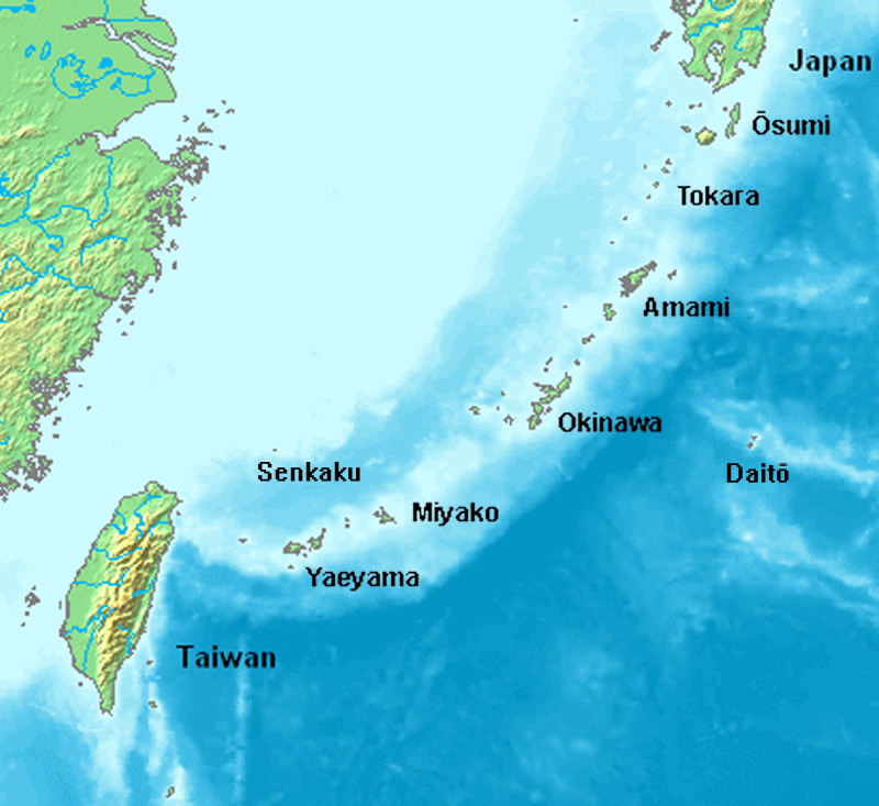
English: Location map of the Ryukyu islands (Nansei islands). This is a modification of the:
http://commons.wikimedia.org/wiki/Image:Location_Ryukyu_Islands.PNG |
| Date | June 2006 |
| Source | Own work |
| Author | Uchinanchu |
| Other versions |
|

Licensing

|
The copyright holder of this work allows anyone to use it for any purpose including unrestricted redistribution, commercial use, and modification.
Usage notes:
|
File history
Click on a date/time to view the file as it appeared at that time.
| Date/Time | Thumbnail | Dimensions | User | Comment | |
|---|---|---|---|---|---|
| current | 16:43, 7 August 2019 | | 800 × 733 (310 KB) | Artanisen | Higher quality and larger version. |
| 05:24, 28 June 2006 |  | 482 × 377 (47 KB) | Uchinanchu | Location of the Ryukyu Islands Modification of the: http://commons.wikimedia.org/wiki/Image:Location_Ryukyu_Islands.PNG |
File usage
The following 3 pages use this file:
Global file usage
The following other wikis use this file:
- Usage on af.wikipedia.org
- Usage on ang.wikipedia.org
- Usage on ar.wikipedia.org
- Usage on ast.wikipedia.org
- Usage on az.wikipedia.org
- Usage on bg.wikipedia.org
- Usage on bh.wikipedia.org
- Usage on br.wikipedia.org
- Usage on ca.wikipedia.org
- Usage on cdo.wikipedia.org
- Usage on da.wikipedia.org
- Usage on de.wikipedia.org
- Ryūkyū-Inseln
- Geschichte der Ryūkyū-Inseln
- Nansei-Inseln
- Kerama-Inseln
- Diploderma polygonatum
- Plestiodon kishinouyei
- Sinomicrurus japonicus
- Eigentliche Zwergschlangen
- Calamaria pfefferi
- Achalinus werneri
- Lycodon multifasciatus
- Ptyas herminae
- Hebius pryeri
- Hebius ishigakiensis
- Hebius concelarus
- Gekko vertebralis
- Ateuchosaurus pellopleurus
- Scincella boettgeri
- Plestiodon japonicus
- Plestiodon marginatus
- Plestiodon latiscutatus
- Plestiodon finitimus
- Plestiodon kuchinoshimensis
- Plestiodon stimpsonii
- Plestiodon takarai
- Plestiodon oshimensis
- Buergeria japonica
- Japanisch-taiwanische Beziehungen
- Usage on en.wikipedia.org
View more global usage of this file.