
File:Narita International Airport landsat.jpg
No higher resolution available.
Narita_International_Airport_landsat.jpg (450 × 240 pixels, file size: 65 KB, MIME type: image/jpeg)
| This is a file from the Wikimedia Commons. Information from its description page there is shown below. Commons is a freely licensed media file repository. You can help. |
Summary
| Description |
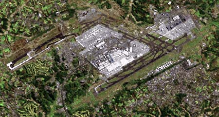
Narita International Airport, Landsat photo (2001). The runway completed in 2002 is visible in the upper half of the photo. 日本語: 成田国際空港ラッドサット画像(2001年)。画像の上半分には建設中の暫定平行滑走路(2002年に供用開始)も見える。 |
||
| Date | |||
| Source |
|
||
| Author | Tdk at Japanese Wikipedia |
Licensing
| This file is licensed under the Creative Commons Attribution-Share Alike 3.0 Unported license. Subject to disclaimers. | ||
| ||
| This licensing tag was added to this file as part of the GFDL licensing update. |

|
Permission is granted to copy, distribute and/or modify this document under the terms of the GNU Free Documentation License, Version 1.2 or any later version published by the Free Software Foundation; with no Invariant Sections, no Front-Cover Texts, and no Back-Cover Texts. A copy of the license is included in the section entitled GNU Free Documentation License. Subject to disclaimers. |
Original upload log
| This file was moved from Japanese Wikipedia.
See below for original file information. | ||||||||||||||||||||||||
| ||||||||||||||||||||||||
|
| ||||||||||||||||||||||||
File history
Click on a date/time to view the file as it appeared at that time.
| Date/Time | Thumbnail | Dimensions | User | Comment | |
|---|---|---|---|---|---|
| current | 08:01, 18 October 2019 | | 450 × 240 (65 KB) | SteinsplitterBot | Bot: Image rotated by 270° |
| 07:45, 26 July 2005 |  | 240 × 450 (65 KB) | Shizhao | 成田国際空港ラッドサット画像(2001年)。画像の上半分には建設中の暫定平行滑走路(2002年に供用開始)も見える。{{landsat}} ja:画像:Narita International Airport landsat.jpg (削除) (最新版) 2005� |
File usage
The following page uses this file:
Global file usage
The following other wikis use this file:
- Usage on de.wikipedia.org
- Usage on fr.wikipedia.org
- Usage on ja.wikipedia.org