
File:Niger river map.svg

Size of this PNG preview of this SVG file: 800 × 503 pixels. Other resolutions: 320 × 201 pixels | 640 × 402 pixels | 1,024 × 644 pixels | 1,280 × 805 pixels | 2,560 × 1,610 pixels | 900 × 566 pixels.
Original file (SVG file, nominally 900 × 566 pixels, file size: 56 KB)
| This is a file from the Wikimedia Commons. Information from its description page there is shown below. Commons is a freely licensed media file repository. You can help. |
| Description |
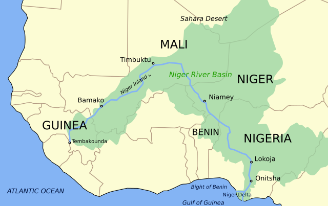
Català: Mapa del riu Níger i la seva conca English: Niger River map (basin included). Retraced into SVG. |
| Date | (UTC) |
| Source | |
| Author |
|
| Other versions |
[]
|


This file is licensed under the Creative Commons Attribution-Share Alike 3.0 Unported license.
- You are free:
- to share – to copy, distribute and transmit the work
- to remix – to adapt the work
- Under the following conditions:
- attribution – You must give appropriate credit, provide a link to the license, and indicate if changes were made. You may do so in any reasonable manner, but not in any way that suggests the licensor endorses you or your use.
- share alike – If you remix, transform, or build upon the material, you must distribute your contributions under the same or compatible license as the original.
Original upload log
This image is a derivative work of the following images:
- File:Niger_river_map.PNG licensed with Cc-by-sa-3.0-migrated, GFDL
- 2006-02-04T08:29:03Z Roke 900x566 (49542 Bytes) Map of the [[w:Niger River]], made by [[User:Astrokey44]] in Corel Painter IX from several sources. [[Category:Maps of Africa]]
Uploaded with derivativeFX
File history
Click on a date/time to view the file as it appeared at that time.
| Date/Time | Thumbnail | Dimensions | User | Comment | |
|---|---|---|---|---|---|
| current | 18:45, 16 September 2023 | | 900 × 566 (56 KB) | Oihanguren | File uploaded using svgtranslate tool (https://svgtranslate.toolforge.org/). Added translation for eu. |
| 11:17, 15 September 2023 |  | 900 × 566 (47 KB) | KajenCAT | File uploaded using svgtranslate tool (https://svgtranslate.toolforge.org/). Added translation for ca. | |
| 21:37, 20 January 2010 |  | 900 × 566 (41 KB) | Wizardist | Smoothless desert label | |
| 21:33, 20 January 2010 |  | 900 × 566 (34 KB) | Wizardist | {{Information |Description=Niger River map (basin included). Retraced into SVG. |Source=*File:Niger_river_map.PNG |Date=2010-01-20 21:32 (UTC) |Author=*author of File:Niger_river_map.PNG *derivative work: ~~~ |Permission=see below |other_versi |
File usage
There are no pages that use this file.
Global file usage
The following other wikis use this file:
- Usage on af.wikipedia.org
- Usage on ar.wikipedia.org
- Usage on arz.wikipedia.org
- Usage on ast.wikipedia.org
- Usage on be-tarask.wikipedia.org
- Usage on be.wikipedia.org
- Usage on ca.wikipedia.org
- Usage on de.wikipedia.org
- Usage on en.wikipedia.org
- Niger River
- Bamako
- Niamey
- Timbuktu
- Onitsha
- Bani River
- Mopti
- National Park of Upper Niger
- Gao
- Ségou
- Kaduna River
- Siguiri
- Lokoja
- Inner Niger Delta
- Tinkisso River
- Escravos River
- Forçados River
- Niger Delta
- Nun River
- Markala
- Kainji Lake
- Sokoto River
- Kouroussa
- Lake Débo
- Niger Basin Authority
- Azawagh
- Template:Niger River
- Sankarani River
- Mékrou River
- Tembakounda
- Kennedy Bridge (Niamey)
- King Fahd Bridge
- Martyrs Bridge (Bamako)
- List of tributaries of the Niger
- River Niger Bridge
- Sota River
- Anambra River
View more global usage of this file.