
File:North Atlantic Treaty Organization (orthographic projection).svg

Size of this PNG preview of this SVG file: 550 × 550 pixels. Other resolutions: 240 × 240 pixels | 480 × 480 pixels | 768 × 768 pixels | 1,024 × 1,024 pixels | 2,048 × 2,048 pixels.
Original file (SVG file, nominally 550 × 550 pixels, file size: 484 KB)
| This is a file from the Wikimedia Commons. Information from its description page there is shown below. Commons is a freely licensed media file repository. You can help. |
Summary
| Description |
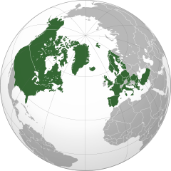
Deutsch: Die Organisation des Nordatlantikvertrags/ North Atlantic Treaty Organization (NATO) in einer orthografischen Projektion.
English: North Atlantic Treaty Organization in orthographic projection.
Español: Organización del Tratado del Atlántico Norte (OTAN).
Français : Projection orthographique de l'Organisation du Traité de l'Atlantique Nord.
Русский: Государства-члены Североатлантического Альянса (НАТО) на карте в ортогональной проекции.
Українська: Проєкція Організації Північноатлантичного договору (НАТО). |
||||
| Date | |||||
| Source |
Own work
|
||||
| Author | Addicted04 | ||||
| SVG development |

.svg)
Licensing
| This map is ineligible for copyright and therefore in the public domain, because it consists entirely of information that is common property and contains no original authorship. For more information, see Commons:Threshold of originality § Maps.
|
File history
Click on a date/time to view the file as it appeared at that time.
.svg&dir=prev)
.svg&offset=20230404124020)
.svg&offset=&limit=20)
.svg&offset=&limit=50)
.svg&offset=&limit=100)
.svg&offset=&limit=250)
.svg&offset=&limit=500)
| Date/Time | Thumbnail | Dimensions | User | Comment | |
|---|---|---|---|---|---|
| current | 01:50, 14 March 2024 | | 550 × 550 (484 KB) | Janitoalevic | . |
| 15:39, 7 March 2024 |  | 550 × 550 (485 KB) | Janitoalevic | . | |
| 15:18, 7 March 2024 |  | 550 × 550 (484 KB) | Janitoalevic | . | |
| 15:17, 7 March 2024 |  | 550 × 550 (472 KB) | Janitoalevic | Added Sweden | |
| 22:33, 23 January 2024 |  | 550 × 550 (470 KB) | Kashmiri | Code optimisations | |
| 03:17, 10 August 2023 |  | 550 × 550 (792 KB) | Chipmunkdavis | Reverted to version as of 20:24, 19 April 2023 (UTC) Rv, adding aspiration, even pending, is undue and potentially misleading on this main prominent map | |
| 23:59, 9 August 2023 |  | 550 × 550 (654 KB) | JordanJames9209 | Pending and aspiring members | |
| 20:24, 19 April 2023 |  | 550 × 550 (792 KB) | Delusion23 | Remove faint outline of Transylvania in Romania | |
| 12:46, 4 April 2023 |  | 550 × 550 (791 KB) | Czello | Reverted to version as of 12:15, 4 April 2023 (UTC) *now* a member | |
| 12:40, 4 April 2023 |  | 550 × 550 (849 KB) | Czello | Reverted to version as of 12:11, 4 April 2023 (UTC) Not yet a member, let's not jump the gun |
File usage
The following page uses this file:
Global file usage
The following other wikis use this file:
- Usage on als.wikipedia.org
- Usage on an.wikipedia.org
- Usage on ar.wikipedia.org
- Usage on ar.wikinews.org
- Usage on as.wikipedia.org
- Usage on azb.wikipedia.org
- Usage on az.wikipedia.org
- Usage on ba.wikipedia.org
- Usage on bcl.wikipedia.org
- Usage on be-tarask.wikipedia.org
- Usage on be.wikipedia.org
- Usage on bg.wikipedia.org
- Usage on bh.wikipedia.org
- Usage on bn.wikipedia.org
- Usage on bs.wikipedia.org
- Usage on bxr.wikipedia.org
- Usage on ca.wikipedia.org
- Usage on ca.wikinews.org
- Usage on cbk-zam.wikipedia.org
- Usage on cdo.wikipedia.org
- Usage on ceb.wikipedia.org
- Usage on ce.wikipedia.org
- Usage on ckb.wikipedia.org
- Usage on cs.wikipedia.org
- Usage on cy.wikipedia.org
- Usage on da.wikipedia.org
- Usage on de.wikipedia.org
- Usage on de.wikinews.org
- Usage on el.wikipedia.org
- Usage on en.wikipedia.org
- Hegemony
- Power (international relations)
- Collective security
- List of European countries by membership in international organisations
- Nuclear-weapon-free zone
- User:Yulia Romero
- User:Manuela Listkiewska
- List of regional organizations by population
- User:Mona23653
- Template:User Ukraine NATO
- User:Yulia Romero/OpinionsOfYulia Romero
- Wikipedia:Userboxes/Politics by country
- User:Kitola
View more global usage of this file.
.svg)
.svg)