
File:POL Lipno (jezioro w województwie pomorskim) 02.jpg

Size of this preview: 450 × 600 pixels. Other resolutions: 180 × 240 pixels | 360 × 480 pixels | 576 × 768 pixels | 768 × 1,024 pixels | 2,448 × 3,264 pixels.
Original file (2,448 × 3,264 pixels, file size: 1.7 MB, MIME type: image/jpeg)
| This is a file from the Wikimedia Commons. Information from its description page there is shown below. Commons is a freely licensed media file repository. You can help. |
 This is Commons' file N⁰ 10,000,000.
Summary
| Description |
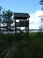
Polski: Platforma widokowa do obserwacji ptactwa wodnego nad jeziorem Lipno we Wdzydzkim Parku Krajobrazowym.
Català: Una plataforma d'observació d'aus aquàtiques del Llac Lipno del Parc Natural de Wdzydze al Voivodat de Pomerània (Polònia).
Esperanto: Turo por rigardi akvobirdojn, cxe la Lipno-barajxlago en la parko de protektita pejzagxo Wdzydze.
Français : Une plate-forme d’observation à sauvagines sur le lac Lipno dans le Parc Wdzydze
Italiano: Una piattaforma per l'osservazione degli uccelli acquatici sul lago Lipno, nel parco di Wdzydze
Русский: Вышка для наблюдения за водоплавающими птицами на озере Липно в Польше.
Українська: Майданчик для спостереження за водоплаваюими птахами біля озера Липно в Польщі.
Polski: Platforma widokowa do obserwacji ptactwa wodnego nad jeziorem Lipno we Wdzydzkim Parku Krajobrazowym
Ελληνικά: Turo por rigardi akvobirdojn, cxe la Lipno-barajxlago en la parko de protektita pejzagxo Wdzydze. |
| Date | |
| Source | Own work |
| Author | Leinad |
| Other versions |
Derivative works of this file: |
_02-2.jpg)
_02_(edits).jpg)
_02.jpg)
| Camera location | | View this and other nearby images on: OpenStreetMap |
|---|
_02.jpg¶ms=054.006597_N_0017.832789_E_globe:Earth_type:camera_region:PL-PM_heading:270.00&language=en)
Licensing
This file is licensed under the Creative Commons Attribution-Share Alike 3.0 Unported license.
- You are free:
- to share – to copy, distribute and transmit the work
- to remix – to adapt the work
- Under the following conditions:
- attribution – You must give appropriate credit, provide a link to the license, and indicate if changes were made. You may do so in any reasonable manner, but not in any way that suggests the licensor endorses you or your use.
- share alike – If you remix, transform, or build upon the material, you must distribute your contributions under the same or compatible license as the original.
This photo of Kashubia, Pomerelia and Żuławy Wiślane was taken during Wikiekspedycja 2010 set up by Wikimedia Polska Association. You can see all photographs in category Wikiekspedycja 2010.
|
The making of this document was supported by Wikimedia Polska.
|
File history
Click on a date/time to view the file as it appeared at that time.
| Date/Time | Thumbnail | Dimensions | User | Comment | |
|---|---|---|---|---|---|
| current | 04:44, 14 June 2011 | | 2,448 × 3,264 (1.7 MB) | ZooFari | Reverted to version as of 23:12, 15 April 2011 (See talk page) |
| 07:03, 20 April 2011 |  | 2,448 × 3,264 (4.63 MB) | 99of9 | Some chromatic aberration correction. There's plenty more if others want to have a go. | |
| 09:51, 16 April 2011 |  | 2,448 × 3,264 (4.63 MB) | Amada44 | further color correction | |
| 00:25, 16 April 2011 |  | 2,448 × 3,264 (3.97 MB) | DerHexer | changed colour, brightness, etc. (feel free to revert) | |
| 23:12, 15 April 2011 |  | 2,448 × 3,264 (1.7 MB) | Leinad |
File usage
The following page uses this file:
Global file usage
The following other wikis use this file:
- Usage on bs.wikipedia.org
- Usage on da.wikipedia.org
- Usage on de.wikipedia.org
- Usage on en.wikipedia.org
- Usage on eo.wikinews.org
- Usage on fr.wikipedia.org
- Usage on fr.wikinews.org
- Usage on nl.wikipedia.org
- Usage on nl.wikimedia.org
- Usage on pl.wikipedia.org
- Usage on pl.wikinews.org
- Usage on ru.wikimedia.org
- Usage on ru.wikinews.org
- Usage on strategy.wikimedia.org
- Usage on sv.wikipedia.org
- Usage on uk.wikipedia.org
_02.jpg)