
File:Sepang.svg

Size of this PNG preview of this SVG file: 727 × 599 pixels. Other resolutions: 291 × 240 pixels | 582 × 480 pixels | 931 × 768 pixels | 1,242 × 1,024 pixels | 2,484 × 2,048 pixels | 1,146 × 945 pixels.
Original file (SVG file, nominally 1,146 × 945 pixels, file size: 54 KB)
| This is a file from the Wikimedia Commons. Information from its description page there is shown below. Commons is a freely licensed media file repository. You can help. |
Summary
Licensing
| Description |
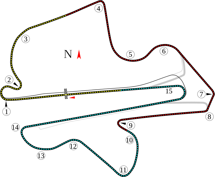
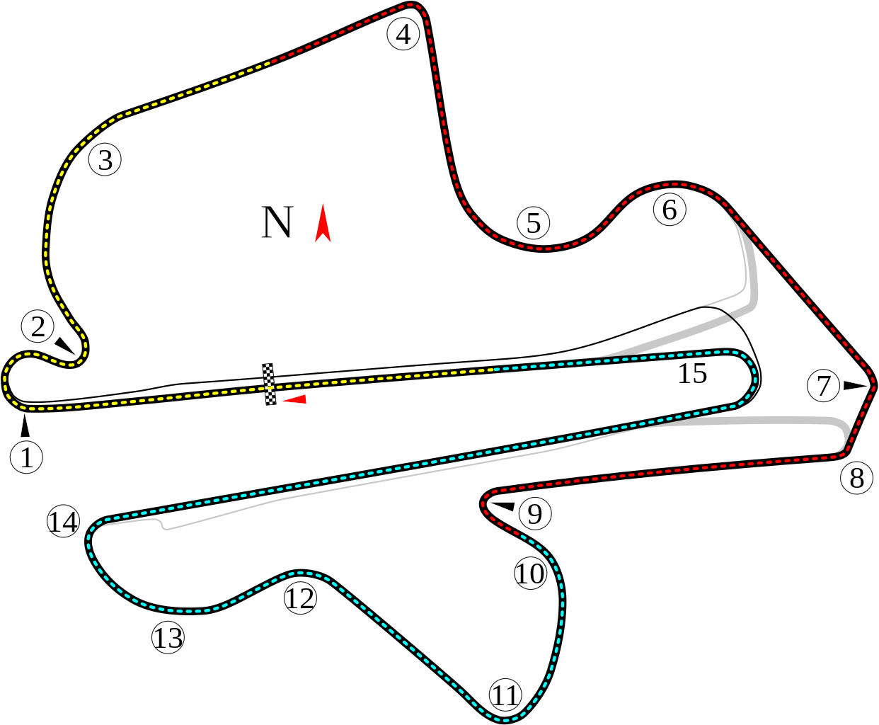
English: Track map for Sepang International Circuit.
Bahasa Melayu: Track peta untuk Litar Antarabangsa Sepang. |
| Date | |
| Source | Own work |
| Author | Will Pittenger |
| Other versions |
|


| Camera location | | View this and other nearby images on: OpenStreetMap |
|---|
Licensing
This file is licensed under the Creative Commons Attribution-Share Alike 3.0 Unported license.
- You are free:
- to share – to copy, distribute and transmit the work
- to remix – to adapt the work
- Under the following conditions:
- attribution – You must give appropriate credit, provide a link to the license, and indicate if changes were made. You may do so in any reasonable manner, but not in any way that suggests the licensor endorses you or your use.
- share alike – If you remix, transform, or build upon the material, you must distribute your contributions under the same or compatible license as the original.
File history
Click on a date/time to view the file as it appeared at that time.
| Date/Time | Thumbnail | Dimensions | User | Comment | |
|---|---|---|---|---|---|
| current | 10:33, 31 July 2008 | | 1,146 × 945 (54 KB) | Will Pittenger | {{Information |Description={{en|1=Track map for w:Sepang International Circuit.}} |Source=Own work by uploader |Author=Will Pittenger |Date=7-31-2008 |Permission= |other_versions=<gallery>Image:Circuit Sepang.png|Old version - |
File usage
The following 2 pages use this file:
Global file usage
The following other wikis use this file:
- Usage on af.wikipedia.org
- Usage on ar.wikipedia.org
- جائزة ماليزيا الكبرى
- حلبة سيبانغ الدولية
- جائزة ماليزيا الكبرى 1999
- جائزة ماليزيا الكبرى للدراجات النارية 2006
- جائزة ماليزيا الكبرى للدراجات النارية 2002
- جائزة ماليزيا الكبرى للدراجات النارية 2003
- جائزة ماليزيا الكبرى للدراجات النارية 2004
- جائزة ماليزيا الكبرى للدراجات النارية 2005
- جائزة ماليزيا الكبرى للدراجات النارية 2007
- جائزة ماليزيا الكبرى للدراجات النارية 2008
- جائزة ماليزيا الكبرى للدراجات النارية 2009
- جائزة ماليزيا الكبرى للدراجات النارية 2010
- جائزة ماليزيا الكبرى للدراجات النارية 2012
- جائزة ماليزيا الكبرى للدراجات النارية 2013
- جائزة ماليزيا الكبرى للدراجات النارية 2014
- جائزة ماليزيا الكبرى للدراجات النارية 1999
- جائزة ماليزيا الكبرى للدراجات النارية 2000
- جائزة ماليزيا الكبرى للدراجات النارية 2001
- جائزة ماليزيا الكبرى 2015
- جائزة ماليزيا الكبرى 2010
- جائزة ماليزيا الكبرى 2008
- جائزة ماليزيا الكبرى 2007
- جائزة ماليزيا الكبرى 2006
- جائزة ماليزيا الكبرى 2002
- جائزة ماليزيا الكبرى 2001
- جائزة ماليزيا الكبرى 2000
- جائزة ماليزيا الكبرى 2005
- جائزة ماليزيا الكبرى 2004
- جائزة ماليزيا الكبرى 2003
- جائزة ماليزيا الكبرى 2017
- جائزة ماليزيا الكبرى 2016
- جائزة ماليزيا الكبرى 2009
- جائزة ماليزيا الكبرى 2011
- جائزة ماليزيا الكبرى 2012
- جائزة ماليزيا الكبرى للدراجات النارية 2018
- Usage on ast.wikipedia.org
- Usage on be-tarask.wikipedia.org
View more global usage of this file.