
File:Surtsey eruption 1963.jpg

Size of this preview: 800 × 531 pixels. Other resolutions: 320 × 212 pixels | 640 × 425 pixels | 982 × 652 pixels.
Original file (982 × 652 pixels, file size: 146 KB, MIME type: image/jpeg)
| This is a file from the Wikimedia Commons. Information from its description page there is shown below. Commons is a freely licensed media file repository. You can help. |
Summary
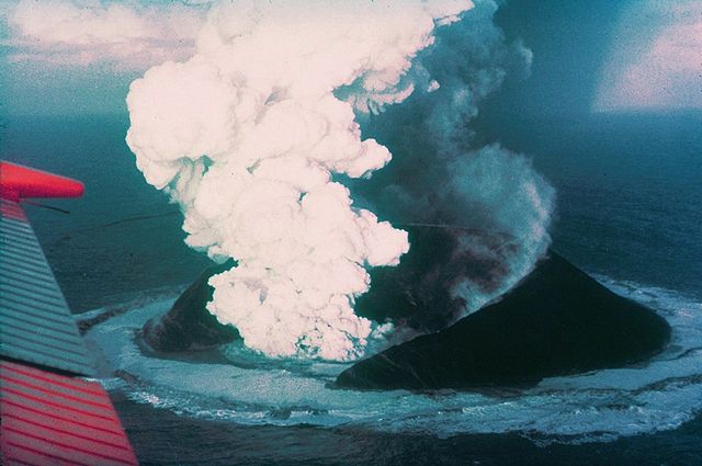
| Description | Surtsey on November 30, 1963, 16 days after the beginning of the eruption. |
| Date | |
| Source | http://www.ngdc.noaa.gov/seg/hazard/slideset/28/28_580_slide.shtml |
| Author | Howell Williams, NOAA |
| Object location | | View this and other nearby images on: OpenStreetMap |
|---|
Licensing
This image is in the public domain because it contains materials that originally came from the U.S. National Oceanic and Atmospheric Administration, taken or made as part of an employee's official duties.
|
File history
Click on a date/time to view the file as it appeared at that time.
| Date/Time | Thumbnail | Dimensions | User | Comment | |
|---|---|---|---|---|---|
| current | 09:29, 1 May 2006 | | 982 × 652 (146 KB) | Wirthi | Surtsey on November 30, 1963, 16 days after the begin of the eruption. Image: Howell Williams. Image source: [http://www.ngdc.noaa.gov/seg/hazard/slideset/28/28_580_slide.shtml NOAA]. {{PD-USGov-DOC-NOAA}} |
File usage
The following page uses this file:
Global file usage
The following other wikis use this file:
- Usage on ab.wikipedia.org
- Usage on af.wikipedia.org
- Usage on ar.wikipedia.org
- Usage on arz.wikipedia.org
- Usage on az.wikipedia.org
- Usage on bg.wikipedia.org
- Usage on ca.wikipedia.org
- Usage on ceb.wikipedia.org
- Usage on ce.wikipedia.org
- Usage on cs.wikipedia.org
- Usage on da.wikipedia.org
- Usage on de.wikipedia.org
- Usage on de.wikivoyage.org
- Usage on el.wikipedia.org
- Usage on en.wikipedia.org
- Surtsey
- Category talk:Geography
- November 1963
- Portal:Geography/Featured article
- Portal:Iceland/Selected article
- Types of volcanic eruptions
- Portal:Iceland/Selected article/1
- Sigurður Þórarinsson
- Portal:Volcanoes/Selected article
- Wikipedia:Today's featured article/November 2008
- Wikipedia:Today's featured article/November 14, 2008
- Portal:Volcanoes/Selected article2
- Portal:Volcanoes/Selected article/15
- Portal:Geography/Featured article/14
- Portal:Islands/Selected article
- Portal:Europe/Featured location
View more global usage of this file.