
File:TS Peter 09 dec 2003 1515Z.jpg

Size of this preview: 600 × 600 pixels. Other resolutions: 240 × 240 pixels | 480 × 480 pixels | 1,000 × 1,000 pixels.
Original file (1,000 × 1,000 pixels, file size: 250 KB, MIME type: image/jpeg)
| This is a file from the Wikimedia Commons. Information from its description page there is shown below. Commons is a freely licensed media file repository. You can help. |
Summary
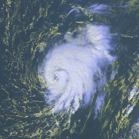
| Description | Tropical Storm Peter was located over the Atlantic Ocean near 20.3S 37.1E at 17:00 UTC. Peter had been moving northward at 10 knots with maximum sustained winds estimated at 60 knots, gusts to 75 knots. | |||
| Date | ||||
| Source | http://www.osei.noaa.gov/Events/Tropical/Atlantic/2003/TRCpeter343_G12.tif | |||
| Author | NOAA / Operational Significant Events Imagery | |||
| Permission (Reusing this file) |
|
File history
Click on a date/time to view the file as it appeared at that time.
| Date/Time | Thumbnail | Dimensions | User | Comment | |
|---|---|---|---|---|---|
| current | 05:48, 23 October 2006 | | 1,000 × 1,000 (250 KB) | Good kitty | == Summary == {{Information |Description=Tropical Storm Peter was located over the Atlantic Ocean near 20.3S 37.1E at 17:00 UTC. Peter had been moving northward at 10 knots with maximum sustained winds estimated at 60 knots, gusts to 75 knots. |Source=htt |
File usage
The following 2 pages use this file:
Global file usage
The following other wikis use this file:
- Usage on en.wikipedia.org
- Usage on es.wikipedia.org
- Usage on fr.wikipedia.org
- Usage on zh.wikipedia.org