
File:US FRONTIER STRIP.PNG
No higher resolution available.
US_FRONTIER_STRIP.PNG (572 × 371 pixels, file size: 15 KB, MIME type: image/png)
| This is a file from the Wikimedia Commons. Information from its description page there is shown below. Commons is a freely licensed media file repository. You can help. |
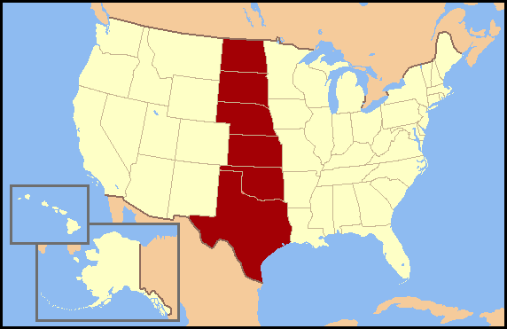
Summary
| Description |
English: Frontier Strip refers to the six U.S. states from North Dakota south to Texas. These states form a nearly straight line from north to south and roughly correspond to the Great Plains region of the United States. The term Frontier Strip is probably correlated to the 1880 census, where these six states, some of which were territories at the time, were part of the "Frontier Line," the geographic designation by the U.S. Census Bureau that proclaimed where the civilitation of the Eastern United States ended and the historic American Wild West began. In the 1890 census, it stated, "Up to and including 1880 the country had a frontier of settlement, but at present the unsettled area has been so broken into by isolated bodies of settlement that there can hardly be said to be a frontier line. In the discussion of its extent, its westward movement, etc., it can not, therefore, any longer have a place in the census reports." NOTE: On 2 January 2018 Wikipedia:Articles for deletion/Frontier Strip determined that "frontier strip" is not actually a recognized geographical term, so this graphic should no longer be used. |
| Source | No machine-readable source provided. Own work assumed (based on copyright claims). |
| Author | No machine-readable author provided. Jannizz assumed (based on copyright claims). |
Licensing
I, the copyright holder of this work, hereby publish it under the following licenses:

|
Permission is granted to copy, distribute and/or modify this document under the terms of the GNU Free Documentation License, Version 1.2 or any later version published by the Free Software Foundation; with no Invariant Sections, no Front-Cover Texts, and no Back-Cover Texts. A copy of the license is included in the section entitled GNU Free Documentation License. |
| This file is licensed under the Creative Commons Attribution-Share Alike 3.0 Unported license. | ||
| ||
| This licensing tag was added to this file as part of the GFDL licensing update. |
You may select the license of your choice.
File history
Click on a date/time to view the file as it appeared at that time.
| Date/Time | Thumbnail | Dimensions | User | Comment | |
|---|---|---|---|---|---|
| current | 15:43, 3 July 2007 | | 572 × 371 (15 KB) | Jannizz | == Summary == Frontier Strip refers to the six U.S. states from North Dakota south to Texas. These states form a nearly straight line from north to south and roughly correspond to the Great Plains region of the United States. The term Frontier Strip i |
File usage
There are no pages that use this file.
Global file usage
The following other wikis use this file:
- Usage on fi.wikipedia.org
- Usage on fr.wikipedia.org
- Usage on he.wikipedia.org
- Usage on ja.wikipedia.org
- Usage on no.wikipedia.org
- Usage on pt.wikipedia.org
- Usage on zh.wikipedia.org