
File:Urbanized population 2006.png

Size of this preview: 800 × 364 pixels. Other resolutions: 320 × 146 pixels | 640 × 292 pixels | 1,024 × 466 pixels | 1,280 × 583 pixels | 3,600 × 1,640 pixels.
Original file (3,600 × 1,640 pixels, file size: 550 KB, MIME type: image/png)
| This is a file from the Wikimedia Commons. Information from its description page there is shown below. Commons is a freely licensed media file repository. You can help. |
Summary
| Description |
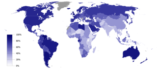
English: Urbanized population percentage by country as of 2006. Source: UNICEF, The State of the World’s Children 2008 (p. 134)
This map was created with GunnMap GunnMap was created by Arthur Gunn and is available, free, at http://gunn.co.nz/map/ and http://gunnmap.herokuapp.com/. Please attribute by linking to http://gunn.co.nz/map/. |
| Date | |
| Source | Based on BlankMap-World6, compact.svg by Canuckguy et al. |
| Author | Jelle564 |
Licensing
| I, the copyright holder of this work, release this work into the public domain. This applies worldwide. In some countries this may not be legally possible; if so: I grant anyone the right to use this work for any purpose, without any conditions, unless such conditions are required by law. |
File history
Click on a date/time to view the file as it appeared at that time.
| Date/Time | Thumbnail | Dimensions | User | Comment | |
|---|---|---|---|---|---|
| current | 13:41, 19 February 2017 | | 3,600 × 1,640 (550 KB) | Zywang114072 | Change and update country urbanized population degree color: Taiwan |
| 16:48, 16 January 2009 |  | 3,600 × 1,640 (362 KB) | Jelle564 | {{Information |Description={{en|1=Urbanized population percentage by country as of 2006. Source: http://www.unicef.org/sowc08/docs/sowc08_table_StatisticalTables.pdf {{GunnMap}}}} |Source=Based on [[:Image:BlankMap-World6, compact.svg|BlankMap-World6, com |
File usage
There are no pages that use this file.
Global file usage
The following other wikis use this file:
- Usage on ar.wikipedia.org
- Usage on bg.wikipedia.org
- Usage on ca.wikipedia.org
- Usage on es.wikipedia.org
- Usage on fa.wikipedia.org
- Usage on gu.wikipedia.org
- Usage on it.wikipedia.org
- Usage on ka.wikipedia.org
- Usage on la.wikipedia.org
- Usage on lt.wikipedia.org
- Usage on nl.wikipedia.org
- Usage on nn.wikipedia.org
- Usage on no.wikipedia.org
- Usage on pl.wikipedia.org
- Usage on pt.wikipedia.org
- Usage on ta.wikipedia.org
- Usage on ur.wikipedia.org