
File:Western sahara walls moroccan.png

Size of this preview: 746 × 600 pixels. Other resolutions: 299 × 240 pixels | 597 × 480 pixels | 904 × 727 pixels.
Original file (904 × 727 pixels, file size: 26 KB, MIME type: image/png)
| This is a file from the Wikimedia Commons. Information from its description page there is shown below. Commons is a freely licensed media file repository. You can help. |
Summary
| Description |
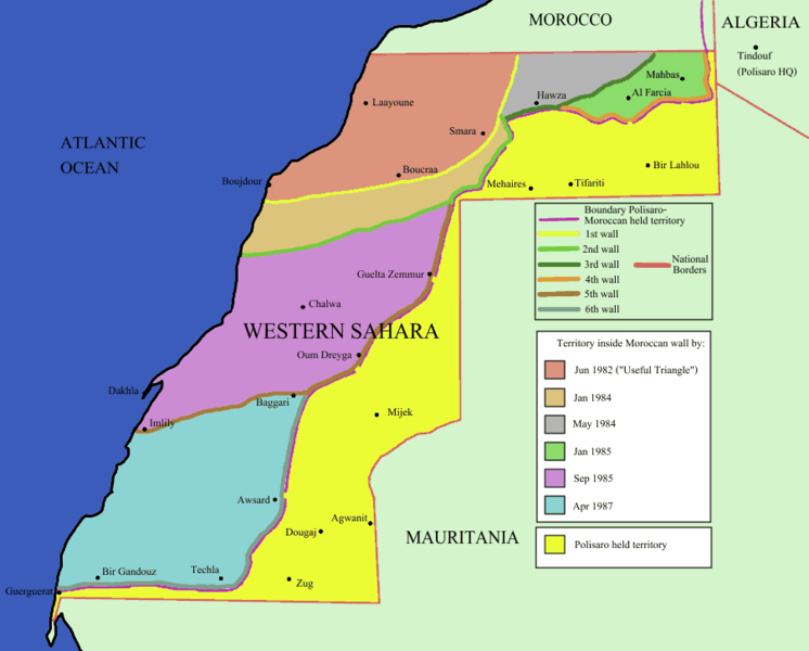
English: Map of the w:Moroccan Defensive Wall in w:Sahara - built over several stages during war against backed Algerian and Libya militias POLISARIO , shows the six Defensive walls built, & when the territory was behind Moroccan defensive wall. Also shows polisaro held territory who are based in Algeria (seen at top right). the map using UN old map map prior to ceasefire , polisario do not hold any territory within Moroccan borders , they are hosted in tindouf camps on Algerian territory [1] and this map [2]. |
|||
| Source | Identical PNG copy of [3] | |||
| Author | User:Roke | |||
| Other versions |
See: Category:Maps of the Moroccan Wall
[]
|


![[2]](https://web.archive.org/web/20110208043824/https://www.marrakech-expedition-4x4.com/images/map.jpg)
Licensing

|
Permission is granted to copy, distribute and/or modify this document under the terms of the GNU Free Documentation License, Version 1.2 or any later version published by the Free Software Foundation; with no Invariant Sections, no Front-Cover Texts, and no Back-Cover Texts. A copy of the license is included in the section entitled GNU Free Documentation License. |
| This file is licensed under the Creative Commons Attribution-Share Alike 3.0 Unported license. | ||
| ||
| This licensing tag was added to this file as part of the GFDL licensing update. |
File history
Click on a date/time to view the file as it appeared at that time.
| Date/Time | Thumbnail | Dimensions | User | Comment | |
|---|---|---|---|---|---|
| current | 13:44, 10 December 2009 | | 904 × 727 (26 KB) | Reisio | == {{int:filedesc}} == Map of the w:Moroccan Wall in w:Western Sahara - built over several stages, shows the six walls built, & when the territory was behind Moroccan wall. Also shows polisaro held territory who are based in Algeria (seen at top r |
File usage
There are no pages that use this file.
Global file usage
The following other wikis use this file:
- Usage on es.wikipedia.org