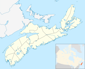
Freeport, Nova Scotia
Freeport | |
|---|---|
Village | |
| Coordinates: 44°16′27″N 66°19′18″W / 44.27417°N 66.32167°W | |
| Country | |
| Province | |
| County | Digby |
| Municipality | Digby |
| Founded | 1784 |
| Area | |
| • Total | 7.57 km2 (2.92 sq mi) |
| Elevation | 0- 5 m (−16 ft) |
| Population (2006) | |
| • Total | 291 |
| • Density | 38.4/km2 (99/sq mi) |
| Time zone | UTC-4 (AST) |
| • Summer (DST) | UTC-3 (ADT) |
| Canadian Postal code | B0V 1B0 |
| Area code | 902 |
| Telephone Exchange | 839 |
| NTS Map | 021B08 |
| GNBC Code | CAMZW |
Freeport, Nova Scotia is a village in Digby Country, Nova Scotia and it is located on Long Island in the Bay of Fundy.
Located at the end of Digby Neck on Long Island, Freeport is a working fishing village built up around a tidal basin. This area is great for bird watching, beach combing, hiking trails, birds, whale watching, gift shops, accommodations, restaurants, and unique flora and fauna.
History[change | change source]
Loyalists founded Freeport in 1784 establishing fishing and trading industries. Prior to this it had been inhabited by the Mi’kmaq Indians. Place names such as Petit Passage, Grand Passage and the Saint Mary’s Bay can be attributed to the French explorer, Champlain, who first visited the area in 1604. Black Loyalist, Rose Fortune is believed to have lived here in 1795, giving birth to one of her children.[1]
References[change | change source]
- ↑ Thompson, Brenda J (2019). Finding Fortune: Documenting and Imagining the LIfe of Rose Fortune (1774-1864). Halifax, Nova Scotia: SSP Publications. pp. 78–79. ISBN 978-1-989347-04-1.

