
Gourdon, Lot
Gourdon | |
|---|---|
_Gourdon_vers_le_sud.jpg) The city and the St Peter church | |
.svg) Coat of arms | |
Location of Gourdon  | |
 Gourdon  Gourdon | |
| Coordinates: 44°44′14″N 1°22′57″E / 44.7371°N 1.3825°E | |
| Country | France |
| Region | Occitanie |
| Department | Lot |
| Arrondissement | Gourdon |
| Canton | Gourdon |
| Intercommunality | Quercy-Bouriane |
| Government | |
| • Mayor (2014-2020) | Marie-Odile Delcamp |
| Area 1 | 45.52 km2 (17.58 sq mi) |
| Population (2014) | 4,297 |
| • Density | 94/km2 (240/sq mi) |
| Demonym | Gourdonnais |
| Time zone | UTC+01:00 (CET) |
| • Summer (DST) | UTC+02:00 (CEST) |
| INSEE/Postal code | 46127 /46300 |
| Elevation | 130–323 m (427–1,060 ft) (avg. 227 m or 745 ft) |
| Website | www.gourdon.fr |
| 1 French Land Register data, which excludes lakes, ponds, glaciers > 1 km2 (0.386 sq mi or 247 acres) and river estuaries. | |
Gourdon (Occitan: Gordon) is a commune in southern France in the region of Occitanie. It is the sous-prefecture (capital) of the arrondissement and canton of the same name in the Lot department.
The town is on a hill, like an acropolis; from here, it is possible to see for about 20 km (12 mi) the landscape of the surrounding region.
Geography[change | change source]
Gourdon is the capital of the Bouriane (a sandy natural region of southwestern France) which is part of the Quercy and that goes up to the Dordogne river and that is next to the Périgord, which is a natural region and old province of France.
The town is in the middle of the commune, above the right side of the Bléou, a stream tributary of the Céou river, which forms most of the commune's southern border.
The commune has an area of 45.52 km2 (17.58 sq mi) and its average altitude is 230 m (750 ft); at the city hall, the altitude is 260 m (850 ft).[1]

|
The commune is at 45 km (28 mi) of Cahors and is surrounded by the communes Payrignac, Anglars-Nozac, Le Vigan, Saint-Cirq-Souillaguet, Saint-Clair, Concorès, Dégagnac and Léobard.
Places next to Gourdon, Lot | |
|---|---|
Climate[change | change source]
The climate of Gourdon, in the Köppen climate classification, is Cfb - Oceanic climate with template summers.
The average amount of precipitation for the year in Gourdon is 856 mm (33.7 in). The month with the most precipitation on average is May with 88.9 mm (3.5 in) of precipitation. The month with the least precipitation on average is February with an average of 55.9 mm (2.2 in). There are an average of 168.0 days of precipitation, with the most precipitation occurring in January with 17.0 days and the least precipitation occurring in July with 10.0 days.[2]
The average temperature for the year in Gourdon is 12.8 °C (55.0 °F). The warmest month, on average, is July with an average temperature of 20.9 °C (69.6 °F). The coolest month on average is January, with an average temperature of 5.2 °C (41.4 °F).[2]
| Climate data for Gourdon, France | |||||||||||||
|---|---|---|---|---|---|---|---|---|---|---|---|---|---|
| Month | Jan | Feb | Mar | Apr | May | Jun | Jul | Aug | Sep | Oct | Nov | Dec | Year |
| Average high °C (°F) | 8.7 (47.7) |
10.6 (51.1) |
14.2 (57.6) |
16.9 (62.4) |
21.0 (69.8) |
24.6 (76.3) |
27.4 (81.3) |
27.1 (80.8) |
23.5 (74.3) |
18.7 (65.7) |
12.3 (54.1) |
9.2 (48.6) |
17.8 (64.1) |
| Daily mean °C (°F) | 5.2 (41.4) |
6.2 (43.2) |
9.1 (48.4) |
11.5 (52.7) |
15.3 (59.5) |
18.5 (65.3) |
20.9 (69.6) |
20.6 (69.1) |
17.5 (63.5) |
14.0 (57.2) |
8.5 (47.3) |
5.8 (42.4) |
12.8 (55.0) |
| Average low °C (°F) | 1.6 (34.9) |
1.8 (35.2) |
3.9 (39.0) |
6.0 (42.8) |
9.5 (49.1) |
12.4 (54.3) |
14.3 (57.7) |
14.1 (57.4) |
11.4 (52.5) |
9.2 (48.6) |
4.6 (40.3) |
2.3 (36.1) |
7.6 (45.7) |
| Average rainfall mm (inches) | 62.5 (2.46) |
55.8 (2.20) |
60.9 (2.40) |
85.1 (3.35) |
87.9 (3.46) |
79.0 (3.11) |
60.0 (2.36) |
63.6 (2.50) |
77.6 (3.06) |
78.3 (3.08) |
74.6 (2.94) |
71.4 (2.81) |
856.7 (33.73) |
| Source: Weatherbase.com [1] | |||||||||||||
Population[change | change source]
The inhabitants of Gourdon are known, in French, as Gourdonnais (women: Gourdonnaises).[3]
With a population of 4,297,[4] Gourdon has a population density of 94 inhabitants/km2.
Evolution of the population in Gourdon

Sister cities[change | change source]
Gallery[change | change source]
-
 Town Hall, Gourdon.
 -

-
 Saint-Pierre church in Gourdon. Interior.
 -
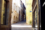 Majou street, Gourdon.

_Fa%C3%A7ace.jpg)
_Interieur_Nef.jpg)

Related pages[change | change source]
References[change | change source]
- ↑ "Gourdon". Map-France.com. Retrieved 2 July 2014.
- ↑ 2.0 2.1 "Gourdon, France - Köppen Climate Classification". Weatherbase. Retrieved 27 February 2017.
- ↑ "Gourdon (46300)" (in French). habitants.fr. Retrieved 2 July 2014.
- ↑ "Régions, départements, arrondissements, cantons et communes" (PDF). Populations légales 2014 (in French). Institut national de la statistique et des études économiques - INSEE. Retrieved 27 February 2017.
- ↑ "Jumelage". Commune de Gourdon, Lot. Retrieved 2 July 2014.
Other websites[change | change source]
- City Council website (in French)
- Pays de Gourdon tourist office (in French)
- Städtepartnerschaft - Jumelage Ibbenbüren - Gourdon (in French)