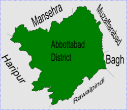
Jarral, Khyber Pakhtunkhwa
Jarral | |
|---|---|
 Jarral is in Abbottabad District | |
| Coordinates: 34°9′0″N 73°3′0″E / 34.15000°N 73.05000°E[2] | |
| Country | Pakistan |
| Province | Khyber Pakhtunkhwa |
| District | Abbottabad |
| Tehsil | Abbottabad |
| Government | |
| • Nazim | Gul Riaz Akhtar Khan |
| • Naib Nazim | Malik Zafar Ali |
| Population | |
| • Total | 6,945[1] |
The Union Council of Jarral is one of the 51 Union Councils of Abbottabad District in the Khyber Pakhtunkhwa province of Pakistan.[3]
Location[change | change source]
Jarral is 35 km from the city of Abbottabad. It is also approachable from Haripur, which is about 25 Kilometer from the town. It is in a valley which is surrounded by large forested mountains on three sides. These forests have a number of wild animals, such as jackals, wolves, pigs, porcupines and sometimes tigers. On the south of the valley there is the famous Tarbela Dam Jheel. The southern area of Jarral UC borders Haripur District. Jabbi is a scenic hill station in the suburbs of Jarral. Jarral has many small related areas:
- Jabbi
- Heeraan
- Jabri
- Bandi Dara
- Nara Doga
- Sorha Dara
- Punj-khoeeyan
- Swayee Dara
- Pujwar
- Kachian
- Tarhaqi
- Thalian
People[change | change source]
Jarral has a population of over 10,000. The local language is Hindko while Urdu and English are understood. The Tanoli is the main tribe of Jarral. But there is significant number of Awans and Syeds. A lot of people from Jarral are living abroad in countries like USA, UK, UAE, Saudi Arabia and other countries around the globe. Jarral is the main market area and people from nearby come to shop. A very beautiful mosque, the Jamia Masjid Jarral, is of historic and architectural significance. It is well known for old-styled wooden door, which is a mater piece of carved art on wood. This old town has also relics of thousands of years old deserted town on a nearby hill on west side.
Farming[change | change source]
Locals grow crops such as maize (makai) and wheat (kanak). Different vegetables are also grown by people for their own use.
Education[change | change source]
There are four schools in Jarral: Government Primary School for Boys, Govt High School for Boys, Govt Girls High School and Fatima Jinnah Public School Jarral (English Medium). Adult Literacy rate in Jarral is more than 80%.
Subdivisions[change | change source]
The Union Council is made up of the following areas: Bacha Sani, Kachhian, Pajwarh, Gul Bandi, Jabbi, Jarral, Khuliala, Bandi Dara, Sohai Dara, Sorha Dara, Kotnali and Nakhey Syedan.[1]
References[change | change source]
- ↑ 1.0 1.1 Union Council Jarral[permanent dead link]
- ↑ Falling Rain - Location of Jarral
- ↑ "Administrative Units of District Abbottabad". Archived from the original on 2007-04-03. Retrieved 2008-08-01.
