
Jurassic Coast


The Jurassic Coast is a stretch of coast in south-west England. It is between Orcombe Point near Exmouth in East Devon and Old Harry Rocks near Swanage in East Dorset. This is 96 miles long (154 km).
It is a UNESCO World Heritage Site.[1]
Its entire length can be walked on the South West Coast Path.[2]
Major fossil finds[change | change source]
Some of the greatest fossil discoveries were made in this area.
- The first ichthyosaur skeleton
- The first plesiosaur
- The first pterosaur outside Germany
These finds were by Mary Anning in the first part of the 19th century. This area was home to Mary, a collector who searched for fossils of the coastline around Lyme Regis and discovered several complete Ichthyosaur fossils.
Geology[change | change source]
.jpg)
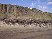
The Jurassic Coast is made of Triassic, Jurassic and Cretaceous cliffs, spanning 185 million years of geological history.
The site contains a number of special features and shows different landforms, including the natural arch at Durdle Door, the cove and limestone folding at Lulworth Cove and an island, the Isle of Portland.
Chesil Beach (or Chesil Bank) is one of England's three shingle (gravel) beaches. It is a barrier beach which runs parallel to the coastline and connects to Portland Bill (see photo). Between the barrier and the regular coastline is a lagoon.
Golden Cap is the highest place on the south coast of England. It is 191 metres (627 ft) high.
Sequence of rocks[change | change source]
This section notes the main rocks found on the coast, starting with the lowest (earliest).
Blue Lias[change | change source]

The Blue Lias is a geologic formation in the Jurassic Coast and parts of south Wales. It is part of the Lias Group.
The Blue Lias consists of a sequence of limestone and shale layers. It was laid down in late Triassic and early Jurassic times, between 195 and 200 million years ago. The Blue Lias is famous for its fossils, especially ammonites. Also found were remains of a number of dinosaurs, and the pterosaur Dimorphodon.
The Blue Lias alternates between limestone, (with some clay), and mudstone.
Gateway towns[change | change source]
These are special towns that are related to the Jurassic Coast:
- Weymouth
- West Bay
- Abbotsbury
- Bridport
- Budleigh Salterton
- Charmouth — Charmouth Heritage Coast Centre
- Exmouth
- Lulworth
- Lyme Regis
- Seaton
- Sidmouth
- Swanage
Pretty much the same rocks can be seen near the Yorkshire coast near Hull (Kingston upon Hull) in Yorkshire near the Humber Estuary. Also the Jurassic and Cretaceous rocks can be followed into northern France.[3]
Gallery[change | change source]
-

-
 The Jurassic limestones on the Isle of Portland.
 -

-
 Landslip near Lyme Regis
 -
 Man O War Cove
 -
 Old harry rocks
 -
 Lyme Regis, England
 -
 Ammonite from the Jurassic Coast, Dorset.
.jpg)


Related pages[change | change source]
References[change | change source]
- ↑ UNESCO, "Dorset and East Devon Coast"; retrieved 2012-4-19.
- ↑ "The Official Guide to the SWCP". SWCP Team. 2004. Retrieved 2007-01-14.
- ↑ For example, see maps of France with colours showing where the rocks are.
Other websites[change | change source]
- Jurassic Coast official website Archived 2008-05-09 at the Wayback Machine
- The South West Coast Path National Trail
- Jurassic Coast UNESCO World Heritage site datasheet
