
Kargil district
Kargil
करगिल | |
|---|---|
 Kargil | |
.svg) Map of Kargil district in Ladakh | |
| Coordinates: 34°01′N 76°24′E / 34.017°N 76.400°E | |
| Country | |
| Union Territory | Ladakh |
| District | Kargil |
| Headquarters | Kargil |
| Area | |
| • Total | 14,036 km2 (5,419 sq mi) |
| Elevation | 2,676 m (8,780 ft) |
| Population (2011)[1] | |
| • Total | 140,802 |
| • Density | 10/km2 (26/sq mi) |
| Languages | |
| • Spoken | Purik, Hindi/Urdu, Sheena, Balti |
| Time zone | UTC+5:30 (IST) |
| PIN Code | 194103 |
| Vehicle registration | LA 02 |
| Website | www |
Kargil is a district in the Indian union territory of Ladakh. Kargil lies near the Line of Control and is surrounded by the Pakistan-administered region of Gilgit–Baltistan to the north, the Kashmir Valley and Jammu divisions to the west, Leh district to the east and Himachal Pradesh to the south. Kargil is divided into 9 blocks which are, Kargil, Drass, Sankoo, Taisuru, Shargole, Shakar-Chiktan, Zanskar, GM Pore/Trespone and Lungnak.[2] It has three Tehsils, namely Kargil, Zanskar and Sankoo. Zanskar and Drass are also sub divisions, and are headed administratively by a Sub Divisional Magistrate.[2]
Name[change | change source]
The name Kargil is said to derive from the Balti-Tibetan words Khar and Rkil. Khar means "Castle" and rkil means "Centre" - thus a place between castles (as the place lay between many kingdoms). The ancient name of Kargil was Purig.
Demographics[change | change source]
With a population of 140,000 Kargil is the only Muslim majority district in Ladakh. Of total population, 85% are Muslim, of which 73% follow Shia Islam. Most of the district's Muslims are found in Kargil town, Drass, Wakha and the lower Suru valley. The remainder 14% are followers of Tibetan Buddhism and Bön, mostly found in Zanskar with small populations in the upper Suru valley (Rangdum) and around Shergol and Mulbekh. Another 1% of the population follow Hinduism and Sikhism.
Purig and Balti people of Tibetan origin (converting from Buddhism to Islam in the 16th Century) mainly live in Kargil. They have mixed with the Dard, Mon and other Aryan people. The mainly Muslim Dards live in the valley of Drass and speak Shina. A small number of Buddhist Dard, known as Brokpa, live in the Dha-Hanu region near the Lamayuru monastery. Some Arghons also live in in Kargil Town. Of late, immigrants from Kashmir and Hindus Jammu have come to live in in Kargil.
Gallery[change | change source]
-
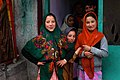 Local girls in Kargil
 -
 buddhist girl dancing on a folk song
 -
-

-
 View of Suru Valley
 -
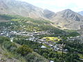
 Panorama of Kargil Town
 -
 Lifeline of Ladakh region - the Zoji La
 -
 Poyen Village
 -
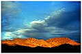 Sunset in the mountains
 -
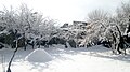 Kargil in the winter
 -
 The Kun and Nun mountain range in Kargil.
 -
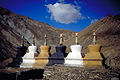 Row of chortens (or stupas) at the village of Purne. Each of the elements that constitute these edifices, as well as their colour, has a symbolic meaning in Tibetan Buddhism.
 -
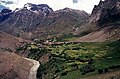 Farmland in Kargil lies straddled below the mountains and above a flowing stream.


.jpg)


References[change | change source]
- ↑ "Census of India 2011 - JAMMU & KASHMIR" (PDF). DIRECTORATE OF CENSUS OPERATIONS JAMMU & KASHMIR. Retrieved 16 July 2016.
- ↑ 2.0 2.1 "Kargil District Administration". Official website of District Kargil-Ladakh, Jammu & Kashmir. Retrieved 16 July 2016.