La Romana Province
La Romana | |
|---|---|
 Cruise liner in Catalina Island, La Romana, approaching the rocky landscape. | |
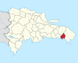
 Location of the La Romana Province | |
| Country | |
| Province since | 1944 |
| Capital | La Romana |
| Government | |
| • Type | Subdivisions |
| • Body | 3 municipalities 2 municipal districts |
| • Congresspersons | 1 Senator 4 Deputies |
| Area | |
| • Total | 653.95 km2 (252.49 sq mi) |
| Population (2014) | |
| • Total | 344,580 |
| • Density | 530/km2 (1,400/sq mi) |
| Time zone | UTC-4 (EST) |
| Area code | 1-809 1-829 1-849 |
| ISO 3166-2 | DO-12 |
| Postal Code | 22000 |
La Romana is a province of the Dominican Republic. It is in the southeastern part of the country. Its capital city has the same name, La Romana.
It was created in 1959. It was a municipality of the El Seibo province before being elevated to the category of province.
Location[change | change source]
La Romana province is in the southeast part of the country. It is bordered to the northwest by the El Seibo province, to the northeast and east by the La Altagracia province and to the west by the San Pedro de Macorís province. The Caribbean Sea is to the south.
History[change | change source]
The province was created in 1944 with the name of La Romana, with two municipalities: La Romana (the capital city) and Higüey; before that date, it was part of the El Seibo province. But that same year, the name of the province was changed to La Altagracia. Its original name was given back to the province in 1961 when the new La Altagracia province was created.
Guaymate was made a municipality of the province in 1971 and Villa Hermosa in 2004. Cumayasa was made a municipal district in 2004 and Caleta in 2006.[1]
Population[change | change source]
In 2014 (last national census), there were 344,580 people living in the La Romana province, and 231,312 (67.1%) living in towns and cities; it is one of the few provinces of the country where most of the people lives in cities. The population density was 528.4 persons/km², one of the highest in the country.[2]
Its population represents 3.65% of the total population of the country and the province is ranked as the 10th (out of 31 plus the National District) more populated province.
As of 2016[update], the total estimated propulation of the province is 262,551 inhabitants.[3]
The largest city of the province is La Romana, its head municipality or capital, with a population (in 2014) of 130,426 inhabitants.[2]
Blacks are the main ethnicity of this providence, at 90% of the population. The rest of the 10% is mostly composed of mulattoes.
Geography[change | change source]
The La Romana province has a total area of 652.1 km2 (251.8 sq mi).[2] It has 1.3% of the area of the Dominican Republic, one of the smallest province of the country, and it is ranked as the 30th (out of 31 plus the National District) largest province.
The altitude of La Romana, provincial capital, is 36 m (118 ft).[4]
There are only a few low hills in the province and almost all the land is flat. The most important rivers are:
- Chavón, in the eastern border of the province;
- Dulce or La Romana, that crosses the capital city; and
- Cumayasa, in the western border of the province.
The small islands of Saona and Catalina are part of the province.
The main protected area in the province is the Parque Nacional del Este ("Eastern National park").
Climate[change | change source]
The climate of the province is a tropical climate, hot most of the year.
Municipalities[change | change source]
There are 3 municipalities and 2 municipal districts (M.D.) in the province.[1] The municipalities and its municipal districts (M.D.) are:

| Municipality (code) |
Municipal Districts (code) | Population (2010) |
Area (km2) |
Density | Altitude (m) |
|---|---|---|---|---|---|
| La Romana (120101) | 130,426 | 267.8 | 487.0 | 36 | |
| Caleta (120102) | 9,245 | 4.5 | 2,054.4 | 3 | |
| La Romana (120100) | 139,671 | 272.2 | 513.1 | ||
| Guaymate (120201) | 16,558 | 262.3 | 63.1 | 88 | |
| Guaymate (120200)) | 16,558 | 262.3 | 63.1 | ||
| Villa Hermosa (120301) | 77,241 | 19.9 | 3,881.5 | 74 | |
| Cumayasa (120302) | 11,963 | 97.7 | 122.4 | 41 | |
| Villa Hermosa (120300) | 89,204 | 117.6 | 758.5 | ||
| La Romana province (120000) | 245,433 | 652.1 | 376.4 | ||
Economy[change | change source]
There are several important industries in the province; the oldest and one of the most important is the production of sugar. There is also a very important zona franca ("free zone" where the industries do not pay taxes and all the production is sent to other countries).
Tourism is very important in the province, around the capital city and with many people going to the beaches in the Saona and Catalina islands.
Related pages[change | change source]
References[change | change source]
- ↑ 1.0 1.1 "División Territorial 2015" (in Spanish). Oficina Nacional de Estadística (ONE). October 2015. Archived from the original (PDF) on 14 November 2015. Retrieved 3 November 2016.
- ↑ 2.0 2.1 2.2 Consejo Nacional de Población y Familia. "Estamaciones y Proyecciones de la Población Dominicana por Regiones, Provincias, Municipios y Distritos Municipales, 2014" (PDF) (in Spanish). Retrieved 2014-02-02.
- ↑ "REPÚBLICA DOMINICANA: Población por año calendario, según sexo y grupos quinquenales de edad, 2015-2020" (in Spanish). Oficina Nacional de Estadística (ONE). Archived from the original (XLS) on 24 June 2016. Retrieved 3 November 2016.
- ↑ "La Romana". Geonames.org. Retrieved 3 November 2016.

