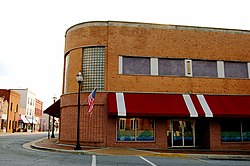
Lawrenceville, Virginia
Lawrenceville, Virginia | |
|---|---|
 Lawrenceville | |
 Location of Lawrenceville, Virginia | |
| Coordinates: 36°45′30″N 77°51′2″W / 36.75833°N 77.85056°W | |
| Country | United States |
| State | Virginia |
| County | Brunswick |
| Area | |
| • Total | 1.15 sq mi (2.98 km2) |
| • Land | 1.15 sq mi (2.98 km2) |
| • Water | 0.00 sq mi (0.00 km2) |
| Elevation | 266 ft (81 m) |
| Population (2020) | |
| • Total | 1,014 |
| • Density | 880/sq mi (340/km2) |
| Time zone | UTC−5 (Eastern (EST)) |
| • Summer (DST) | UTC−4 (EDT) |
| ZIP code | 23868 |
| Area code | 434 |
| FIPS code | 51-44520[2] |
| GNIS feature ID | 1498503[3] |
| Website | https://lawrencevilleweb.us/ |
Lawrenceville is a town in Brunswick County, Virginia, United States. In the 2020 census, 1,014 people lived there.[4] The town is by the Meherrin River. It is the county seat of Brunswick County.[5] In colonial times, Lieutenant Governor Alexander Spotswood had a stockade built nearby. It was called Fort Christanna. At the stockade, converted Native American allies were housed and educated.
Historically black Saint Paul's College operated here until 2013. It was founded in 1888 and affiliated with the Episcopal Church. Lumber, tobacco, livestock and other farm products are grown in the area. The town is in a county along the southern border of the state. It is near the northernmost area for cotton growing.
References[change | change source]
- ↑ "2019 U.S. Gazetteer Files". United States Census Bureau. Retrieved August 7, 2020.
- ↑ "U.S. Census website". United States Census Bureau. Retrieved 2008-01-31.
- ↑ "US Board on Geographic Names". United States Geological Survey. 2007-10-25. Retrieved 2008-01-31.
- ↑ "Lawrenceville town, Virginia". United States Census Bureau. Retrieved December 25, 2022.
- ↑ "Find a County". National Association of Counties. Retrieved 2011-06-07.

