Minnesota River
| Minnesota River Watpá Mnísota | |
|---|---|
 The Mendota Bridge crossing the Minnesota River, just above its mouth | |
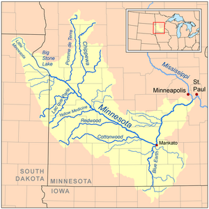
 Map of the Minnesota River | |
| Location | |
| Country | United States |
| State | Minnesota |
| Cities | Bloomington, MN, Eden Prairie, MN, Mankato, MN, Shakopee, MN, Burnsville, MN, Eagan, MN, Le Sueur, MN |
| Physical characteristics | |
| Source | Big Stone Lake |
| - location | Big Stone Lake, Big Stone County, MN |
| - elevation | 964 ft (294 m) |
| Mouth | Mississippi River |
| - location | Near Fort Snelling in Minnesota, Hennepin County, MN |
| - elevation | 690 ft (210 m) |
| Length | 370 mi (600 km) |
| Basin size | 17,000 sq mi (44,000 km2) |
| Discharge | |
| - average | 4,414 cu ft/s (125.0 m3/s) |
The Minnesota River is a river in the United States. It is in the northern United States, in the state of Minnesota. It is a tributary of the Mississippi River. It is about 534 km long.
The source of the river is a lake in western Minnesota. The lake is called Big Stone Lake. The lake is on the border between the state of Minnesota and the state of South Dakota. From its source, the Minnesota flows southeast. At Mankato, it turns northeast. It joins the Mississippi just south of the cities of Saint Paul and Minneapolis.
The Minnesota River was formed after the last ice age in North America.

