Mount Hermon
| Mount Hermon | |
|---|---|
| Arabic: Jabal ash-Shaykh Hebrew: Har Hermon | |
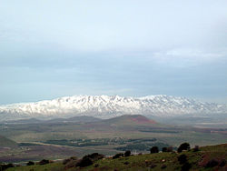
 Mount Hermon, viewed from Mount Bental in the Golan Heights | |
| Highest point | |
| Elevation | 2,814 m (9,232 ft) |
| Prominence | 1,804 m (5,919 ft) |
| Listing | Country high point Ultra |
| Coordinates | 33°24′58″N 35°51′27″E / 33.41611°N 35.85750°E |
| Geography | |
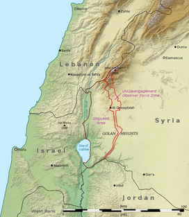
| Location | Syria, Lebanon, Israel |
| Parent range | Anti-Lebanon mountain range |
Mount Hermon (Arabic: جبل الشيخ, Jabal al-Shaykh, "Mountain of the Chief"; Hebrew: הר חרמון, Har Hermon, "Mount Hermon") is a very high mountain cluster in the Eastern Lebanon Mountain Range. Its summit sits on the border between Syria, Lebanon, and the Israeli Golan Heights.[1] At 2,814 metres (9,232 ft) above sea level, it is the highest point in Syria and Israel.[2] The southern slopes of Mount Hermon extend into the Israeli part of the Golan Heights. Most of the mountain peaks are snowy in the winter. Mount Hermon has the highest precipitation in Israel and Syria.
References[change | change source]
- ↑ ACME Mapper terrain display
- ↑ "CIA World Fact Book: Syria". 14 November 2011. Archived from the original on 29 December 2017. Retrieved 27 November 2011.
highest point: Mount Hermon 2,814 m
Other websites[change | change source]
![]() Media related to Mount Hermon at Wikimedia Commons
Media related to Mount Hermon at Wikimedia Commons
- Photos of Mount Hermon ski resort (in a snowless season) Archived 2016-04-11 at the Wayback Machine
- Israeli Hermon sky resort Archived 2013-03-14 at the Wayback Machine

