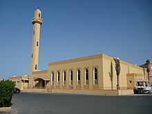
Rumaithiya
Rumaithiya
Ar - Rumaytheeyah Rumaythiyah | |
|---|---|
City | |
| Coordinates: 29°19′N 48°4′E / 29.317°N 48.067°E | |
| Country | Kuwait |
| Province | Hawalli Governorate |
| Government | |
| • Type | Municipality |
| Population | |
| • Total | 58,135 |
| Time zone | GMT+3 |
Rumaithiya is an area in Hawalli governorate in Kuwait. About 58,000 people live there.[1]
Origin of the name[change | change source]
It is believed that the name of the area comes from a plant called Haloxylon. In the Arabic language, the plant is called Rumth. The area used to have this plants in it. Rumaithiya literally means something related to Rumth.
Places[change | change source]

- There are 14 masjids in Rumaithiya
- There are more than 70 Husayniyas in Rumaithiya
- There are 12 branches for Rumaithiya Co-Op society
- There is an area for sports
- There are 2 public parks
- There are 13 schools in Rumaithiya without private schools and children's schools (kindergartens)
Sources[change | change source]
- ↑ "Kumait PACI (2012)". Archived from the original on 2015-03-19. Retrieved 2013-04-13.
Wikimedia Commons has media related to Rumaithiya.

