
Saint-Girons, Ariège
Saint-Girons | |
|---|---|
Subprefecture and commune | |
 View of Saint-Girons and the Sourroque mountain | |
.svg) Coat of arms | |
Location of Saint-Girons  | |
 Saint-Girons  Saint-Girons | |
| Coordinates: 42°59′09″N 1°08′48″E / 42.9858°N 1.1467°E | |
| Country | France |
| Region | Occitanie |
| Department | Ariège |
| Arrondissement | Saint-Girons |
| Canton | Couserans Ouest |
| Intercommunality | Couserans - Pyrénées |
| Government | |
| • Mayor (2014–2020) | François Murillo[1] |
| Area 1 | 19.13 km2 (7.39 sq mi) |
| Population (2014) | 6,284 |
| • Density | 330/km2 (850/sq mi) |
| Demonym | Saint-Gironnais |
| Time zone | UTC+01:00 (CET) |
| • Summer (DST) | UTC+02:00 (CEST) |
| INSEE/Postal code | 09261 /09200 |
| Elevation | 387–1,200 m (1,270–3,937 ft) (avg. 391 m or 1,283 ft) |
| Website | www.ville-st-girons.fr |
| 1 French Land Register data, which excludes lakes, ponds, glaciers > 1 km2 (0.386 sq mi or 247 acres) and river estuaries. | |
Saint-Girons (Gascon: Sent Gironç) is a commune in the Ariège department in the Occitanie region, southwestern France. It is the capital of the former French province of Couserans that forms the western part of Ariège.
History[change | change source]

Unlike its close neighbour Saint-Lizier, Saint-Girons is not an ancient city; there was however a lucus (a "sacred forest") on its present territory.
The city is named after Saint Girons, a saint from fifth-century Landes who evangelized in southwestern France. In the ninth century some of his relics were supposedly buried in Saint Girons' Church,[2] around which the city later developed.
Geography[change | change source]
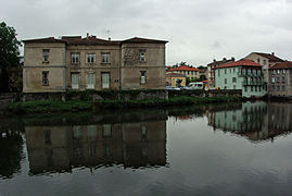
Saint-Girons is in the center of a basin at the foot of the Pyrenees and at the confluence of the Salat with the Lez and Baup rivers, in the Ariège department, southern France. The commune is part of the Regional Natural Park Pyrenees Ariégeoises.
The commune has an area of 19.1 km2 (7.4 sq mi).[3] Its average altitude is 365 m (1,198 ft); at the city hall, the altitude is 390 m (1,280 ft).[4]

|
The commune of Saint-Girons is surrounded by the communes:
Places next to Saint-Girons, Ariège | |
|---|---|
Climate[change | change source]
The climate of Saint-Girons, in the Köppen climate classification, is Cfb - Oceanic climate with template summers.
| Climate data for Saint-Girons | |||||||||||||
|---|---|---|---|---|---|---|---|---|---|---|---|---|---|
| Month | Jan | Feb | Mar | Apr | May | Jun | Jul | Aug | Sep | Oct | Nov | Dec | Year |
| Average high °C (°F) | 9.9 (49.8) |
11.1 (52.0) |
12.9 (55.2) |
15.0 (59.0) |
18.5 (65.3) |
22.0 (71.6) |
25.0 (77.0) |
24.5 (76.1) |
22.9 (73.2) |
18.8 (65.8) |
13.5 (56.3) |
10.4 (50.7) |
17 (63) |
| Daily mean °C (°F) | 5.1 (41.2) |
6.1 (43.0) |
7.7 (45.9) |
10.1 (50.2) |
13.3 (55.9) |
16.7 (62.1) |
19.4 (66.9) |
19.0 (66.2) |
17.0 (62.6) |
13.1 (55.6) |
8.3 (46.9) |
5.5 (41.9) |
11.8 (53.2) |
| Average low °C (°F) | 0.3 (32.5) |
1.1 (34.0) |
2.6 (36.7) |
5.1 (41.2) |
8.1 (46.6) |
11.5 (52.7) |
13.7 (56.7) |
13.6 (56.5) |
11.1 (52.0) |
7.5 (45.5) |
3.1 (37.6) |
0.7 (33.3) |
6.5 (43.7) |
| Average precipitation mm (inches) | 92.5 (3.64) |
78.3 (3.08) |
92.9 (3.66) |
98.3 (3.87) |
108.8 (4.28) |
90.0 (3.54) |
62.4 (2.46) |
74.0 (2.91) |
73.2 (2.88) |
77.5 (3.05) |
77.2 (3.04) |
88.3 (3.48) |
1,013.4 (39.90) |
| Source: Metereological data for Saint-Girons - Antichan from 1961 to 1990 July 2013 | |||||||||||||
Population[change | change source]
_-_%C3%89glise_Saint-Girons_-_20070625.jpg)
The inhabitants of Saint-Girons are known, in French, as Saint-Gironnais or Gironnais (women: Saint-Gironnaises or Gironnaises).[5]
Saint-Girons has a population of 6,284 (2014),[6] and population density of 328 inhabitants/km2.
Evolution of the population in Saint-Girons

Saint-Girons forms, with other 3 communes, the urban area of Saint-Girons with a population of 9,652 inhabitants (2013) and an area of 39.1 km2 (15.1 sq mi).[7] This urban area is the centre of the metropolitan area of Saint-Girons, formed by 39 communes with a population of 18,222 inhabitants (2013) and an area of 440.4 km2 (170.0 sq mi).[8]
Administration[change | change source]
Saint-Girons is a subprefecture of the Ariège department, the capital of the arrondissement of Saint-Girons and the administrative centre (French: chef-lieu) of the canton Couserans Ouest, with 10,686 inhabitants (2014).
It is part of the intercommunality Couserans - Pyrénées (French: Communauté de communes Couserans - Pyrénées).
Twinned and partner towns[change | change source]
Saint-Girons is twinned with:[9]
Sites of interest[change | change source]
Some important buildings are:
- The Saint-Girons church
- The Saint-Valier church
- The Palais de Justice
Gallery[change | change source]
-
 St Girons' Church by the Salat river
 -
 Market in the Gambetta street, Saint-Girons
 -
 Château des Vicomtes, Parc du Tribunal
 -
 Petite Rue des Jacobins, Saint-Girons
 -
 Hall in the Château des Vicomtes

.jpg)
.jpg)
.jpg)
Related pages[change | change source]
References[change | change source]
- ↑ "Le Maire et ses adjoints". Ville Saint-Girons. Retrieved 23 March 2017.
- ↑ "Histoire et patrimoine". Ville Saint-Girons. Retrieved 14 June 2014.
- ↑ "Commune de Saint-Girons (09261)". Comparateur de territoire (in French). Institut national de la statistique et des études économiques - INSEE. Retrieved 23 March 2017.
- ↑ "City of Saint-Girons". Map-France.com. Retrieved 14 June 2014.
- ↑ "Saint-Girons (09200)" (in French). habitants.fr. Retrieved 14 June 2014.
- ↑ "Régions, départements, arrondissements, cantons et communes" (PDF). Populations légales 2014 (in French). Institut national de la statistique et des études économiques - INSEE. Retrieved 13 January 2017.
- ↑ "Unité urbaine de Saint-Girons (09203)". Comparateur de territoire (in French). Institut national de la statistique et des études économiques - INSEE. Retrieved 23 March 2017.
- ↑ "Aire urbaine de Saint-Girons (267)". Comparateur de territoire (in French). Institut national de la statistique et des études économiques - INSEE. Retrieved 23 March 2017.
- ↑ "Jumelages". Ville Saint-Girons. Retrieved 14 June 2014.
Other websites[change | change source]
- City Council website (in French)
- Pays Couserans (in French)
- Saint-Girons in Histariège - Histoire et Patrimoine de l'Ariège Archived 2012-03-31 at the Wayback Machine (in French)