Snowdonia
| Snowdonia Eryri | |
|---|---|
IUCN category V (protected landscape/seascape) | |
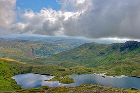
 View of Llyn Llydaw from Crib Goch | |
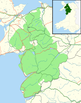
 A map of Snowdonia National Park | |
| Location | Wales |
| Coordinates | 52°54′N 3°51′W / 52.900°N 3.850°W |
| Area | 823 sq mi (2,130 km2) |
| Established | 1951 |
Snowdonia (Welsh: Eryri) is a region in north Wales. It is also a national park of 838 square miles (2,170 square kilometres) in area. It was the first national park in Wales, set up in 1951. It is the largest national park in Wales and includes the highest mountain in Wales, and the largest natural lake in Wales.[1] Before 1951, the word Snowdonia was used for the much smaller area around Snowdon itself. The which includes the national park is twice as large.
Name[change | change source]
The English name for the area comes from Snowdon, which is the highest mountain in Wales, at 3,560 feet (1,090 metres) above sea level. In Welsh it is named Eryri. This could be the Welsh word for eagle, which is eryr, or it may mean highlands.[2] In the Middle Ages, Llywelyn ap Gruffudd, who was the Prince of Wales, was called Prince of Wales and Lord of Snowdonia. In Welsh, it translates to Tywysog Cymru ac Arglwydd Eryri. Gruffudd's grandfather, Llywelyn Fawr, was called "Prince of north Wales and Lord of Snowdonia."
Before it was a national park, the name "Snowdonia" was used to describe "Snowdon," a small area north of Gwynedd. Today, the national park covers an area that is two times larger than the area originally called Snowdonia. The park covers areas as far south as Meirionnydd. The original Snowdonia includes Snowdon, and three other mountain ranges: the Glyderau, the Carneddau and the Moel Siabod group. The hills that are south of Maentwrog are not part of the original Snowdonia.
Snowdonia National Park[change | change source]

Snowdonia National Park (Welsh: Parc Cenedlaethol Eryri) was started in 1951. It was the third national park in Britain. It makes up 827 square miles (2,140 square kilometres), and has 37 miles (60 kilometres) of coastline in its border.[3][4] The park is ran by the Snowdonia National Park Authority. The park has lands that are owned by private people and also by the public.
Snowdonia has many historic sites, including Stone Age burial chambers, Iron age hill forts, Roman forts, churches, and medieval castles. There are also industrial sites including large slate quarries, copper mines, and woolen mills.[5] More than 26,000 people live in Snowdonia.[6][7] The area attracts over six million visitors every year.[8] Most of the land is either open or mountainous land, but there is also some farm-land. Snowdonia National Park does not include the town of Blaenau Ffestiniog, which is like an island in the centre of the park.
Mountain ranges[change | change source]

Snowdonia may be divided into four areas:
- The northern area is the most popular with visitors. It includes Moel Hebog, Mynydd Mawr, the Nantlle Ridge, Snowdon, the Glyderau, and the Carneddau. These are the highest mountains in Wales.
- The second area includes Moel Siabod, Cnicht, the Moelwynion, and the mountains around Blaenau Ffestiniog.
- The third area includes the Rhinogydd and the Arenig. It also includes the bog Migneint and an extinct volcano, Rhobell Fawr. Because it a remote area, there are not many visitors.
- The southern area includes Cadair Idris, the Tarren range, the Dyfi hills, and the Aran group, including Aran Fawddwy.
Hiking[change | change source]

People can hike the area, primarily in Snowdon. People can hike the Snowdon Mountain Railway all the way to the top of the mountain.[9] People also hike other mountains in the area such as Tryfan and lower areas that aren't very mountainous. There are 1,479 miles (2,380 kilometres) of footpaths that go through the park. 164 miles (264 kilometres) bridleways are also in the area for people to ride horses.[10] The park also has many areas that are within Right to Roam laws.
Nature and environment[change | change source]

The coastline in the park is a Special Area of Conservation. The area starts at Llŷn Peninsula and goes down the coast. There are sand dunes located in the special area. The park has trees. They are a mix of different types of deciduous trees. The tree seen the most in the park is the Welsh Oak. Birch, ash, mountain-ash and hazel trees are also found in the park. There are coniferous forests that have been planted by people. These forests include Gwydir Forest. These forests used to be harvested for wood. Now they grow without people cutting down the trees.
The park is the only place in Britain where Snowdon lily and the Snowdon beetle can be found. It is the only place in the world where the Snowdonia hawkweed is found. An invasive species is growing in the park, too, called the Rhododendron ponticum. It kills native species that live in the park and also makes fungus grow that is poisonous. The fungus stays alive up to seven years after the rhododendron is killed.[11]
Animals[change | change source]
Almost 20% of the land in Snowdonia is protected under laws. These laws protect the plants and animals that live in Snowdonia. Half of the 20% of protected land is part of the national park.[12] Otters, polecats, and wild goats live in Snowdonia. So do pine marten's but they are very hard to find and are rare.[13] Other birds that are rare and hard to find are ravens, peregrine, osprey, merlin, and red kites. The Snowdown beetle, which is rainbow colored, also lives in Snowdon.[12]
Weather[change | change source]
Snowdonia is one of the wettest parts of the United Kingdom. The area Crib Goch, which is in Snowdonia, is the wettest place in the UK. It rains, on average, 4,473 millimetres (176.1 inches) a year.[14][15]
References[change | change source]
- ↑ "Eryri". eryri-npa.gov.uk. 2014. Retrieved 28 May 2014.
- ↑ Ifor Williams, Enwau Lleoedd (Liverpool, 1945), p. 18.
- ↑ Culliford, Alison (24 July 1999). "National Parks – The complete guide to Britain's national parks". The Independent. Archived from the original on 25 September 2015. Retrieved 31 August 2017.
- ↑ "Our national parks". MSN. Archived from the original on 2011-10-02. Retrieved 2014-06-11.
- ↑ "A Sense of Place". eryri-npa.gov.uk. 2014. Archived from the original on 9 July 2014. Retrieved 28 May 2014.
- ↑ Thomas, Helen (28 October 2001). "Make the most of Snowdonia". The Independent.
- ↑ "The Welsh Language". Snowdonia National Park Authority. Archived from the original on 2007-10-23. Retrieved 2014-06-11.
- ↑ Park Profile 2007[permanent dead link]. Snowdonia National Park Authority.
- ↑ Parker, Mike; Whitfield, Paul (2003). The Rough Guide to Wales (4 ed.). Rough Guides. pp. 385. ISBN 978-1-84353-120-3.
- ↑ "Walks for region – Snowdonia Mountains and Coast". Walking in North Wales. Archived from the original on 2010-05-05. Retrieved 2014-06-11.
- ↑ "Important plant areas in the UK". The Daily Telegraph. 24 July 2007. Archived from the original on 13 November 2012. Retrieved 1 April 2018.
- ↑ 12.0 12.1 "Wildlife". Snowdonia National Park Authority. Archived from the original on 2 November 2013. Retrieved 19 August 2013.
- ↑ Turner, Robin (3 August 2009). "If you go down to the woods today you might find an endangered pine marten". WalesOnline.
- ↑ Clark, Ross (28 October 2006). "The wetter, the better". The Independent. Archived from the original on 9 January 2015. Retrieved 1 April 2018.
- ↑ Philip, Catherine (28 July 2005). "40 die as one year's rain falls in a day". The Times.
Other websites[change | change source]
- Snowdonia National Park Authority Archived 2007-02-13 at the Wayback Machine
- Snowdonia Society
