
Space Needle
| Space Needle | |
|---|---|
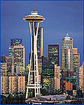
 The Space Needle flying the U.S. flag on Independence Day in 2011 | |
 | |
| Record height | |
| Tallest in Seattle and Washington state from 1962 to 1969[I] | |
| Preceded by | Smith Tower |
| Surpassed by | Safeco Plaza |
| General information | |
| Status | Complete |
| Type | Observation tower |
| Location | 400 Broad Street Seattle, Washington, U.S. |
| Coordinates | 47°37′13″N 122°20′57″W / 47.6204°N 122.3491°W |
| Construction started | April 17, 1961 |
| Completed | December 8, 1961 |
| Opening | April 21, 1962 |
| Owner | Space Needle Corporation |
| Height | |
| Antenna spire | 604 ft (184 m) |
| Top floor | 518 ft (158 m) |
| Technical details | |
| Floor count | 6 |
| Lifts/elevators | 3 |
| Design and construction | |
| Architect | John Graham & Company |
| Structural engineer | John K. Minasian Victor Steinbrueck |
| Main contractor | Howard S. Wright Construction Co |
| Designated | April 19, 1999[1] |
| References | |
| [2][3][4][5][6] | |
The Space Needle is a tower in Seattle, Washington. It is at the Seattle Center. The Space Needle was built for the 1962 World's Fair. During this time, almost 20,000 people used the elevators every day. Over 2.3 million visitors came to the World Fair overall. The Space Needle is 605 feet (184 m) high and 138 feet (42 m) wide. It weighs 9,550 tons. When it was completed it was the tallest building to the west of the Mississippi River.[7] It is built not to fall in wind up to 200 miles per hour (89 m/s) and earthquakes of up to 9.1 magnitude.[8] This gives protection against an earthquake as powerful as the 1700 Cascadia earthquake. The tower also has 25 lightning rods on its roof to protect it against lightning. The tower is topped with an American flag.
The Space Needle has a deck at 520 feet (160 m), where people can look down and look at the view around them. It also has a gift shop with a rotating SkyCity restaurant at 500 feet (150 m).[7] From the top of the Needle, the Downtown Seattle skyline, the Olympic and Cascade Mountains, Mount Rainier, Mount Baker, Elliott Bay and islands around it can be seen. Photographs of the Seattle skyline often show the Space Needle.
Visitors can reach the top of the Space Needle by using elevators. These elevators travel at 10 miles per hour (4.5 m/s). The trip to the top takes 41 seconds. Some tourists wait in hour-long lines so that they can go to the top of the tower. On windy days, the elevators are slowed down to a 5 miles per hour (2.2 m/s). The Space Needle was made a historic landmark on April 19, 1999, by the city's Landmarks Preservation Board.[7][9]
Gallery[change | change source]
-
 The Space Needle in the 1960s.
 -
 Space Needle from Downtown Seattle.
 -
 The gift shop in the Space Needle.
 -
-
 View from the bottom exof the Needle.
 -
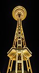
 The Space Needle at night.
 -
 Space Needle at night. This is how it looks from Kerry Park.
 -
 The Space Needle and the elevator during the day.
 -
 The bottom of the Space Needle at night.
 -
 Night view


Related pages[change | change source]
References[change | change source]
- ↑ "Landmarks and Designation". City of Seattle. Archived from the original on 2013-03-06. Retrieved 2013-03-05.
- ↑ "Space Needle". CTBUH Skyscraper Center.
- ↑ Space Needle at Emporis
- ↑ Space Needle at Glass Steel and Stone
- ↑ "Space Needle". SkyscraperPage.
- ↑ Space Needle at Structurae
- ↑ 7.0 7.1 7.2 "Space Needle Fun Facts". Space Needle Official Site. Archived from the original on 2011-04-26. Retrieved 2007-01-12. [*ref failed*]
- ↑ "The Space Needle". U.S. History.com. Retrieved August 29, 2014.
- ↑ "Seattle holds groundbreaking ceremony for the Space Needle on April 17, 1961". HistoryLink.org. Retrieved 2007-01-12.