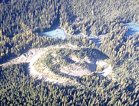
Tseax River Cone
| Tseax Cone | |
|---|---|
 Tseax Cone | |
| Highest point | |
| Elevation | 610 |
| Coordinates | 55°06′39″N 128°53′56″W / 55.11083°N 128.89889°W |
| Geography | |
| Location | British Columbia, Canada |
| Parent range | Nass Ranges |
| Topo map | NTS 103J/2 |
| Geology | |
| Age of rock | Historical |
| Mountain type | Cinder cone |
| Volcanic arc/belt | Northern Cordilleran Volcanic Province |
| Last eruption | 1690 ± 150 years (18th deadliest eruption of all time) |
| Climbing | |
| Easiest route | drive |
The Tseax River Cone (also known as Aiyansh Volcano) is a cinder cone in British Columbia, Canada. The volcano and the area around it are protected as a provincial park called the Nisga'a Memorial Lava Beds Provincial Park. [1]
In the 18th century it caused the death of about 2000 people.
References[change | change source]
- ↑ "Global Volcanism Program | Tseax River Cone". Smithsonian Institution | Global Volcanism Program. Retrieved 2020-06-26.
