
Vézère Valley
| UNESCO World Heritage Site | |
|---|---|
 Vézère at La Madeleine site | |
| Includes | |
| Criteria | Cultural: (i)(iii) |
| Reference | 85 |
| Inscription | 1979 (3rd Session) |
The Vézère Valley is known for its prehistoric cave systems, containing numerous cave paintings and hominid remains. They are found in the valley of the Vézère river between the communes of Les Eyzies-de-Tayac-Sireuil and Montignac in the Dordogne department, Nouvelle-Aquitaine region.
UNESCO designated the systems as a World Heritage Site in 1979. Among the archaeological sites with remarkable caves is Lascaux.
Inscription as a heritage site[change | change source]
UNESCO description is:[1]
- "The Vézère valley contains 147 prehistoric sites dating from the Palaeolithic and 25 decorated caves. It is particularly interesting from an ethnological and anthropological, as well as an aesthetic point of view because of its cave paintings, especially those of the Lascaux Cave, whose discovery in 1940 was of great importance for the history of prehistoric art. The hunting scenes show some 100 animal figures, which are remarkable for their detail, rich colours and lifelike quality".
List of the main sites named by the UNESCO[change | change source]
Gallery[change | change source]
-
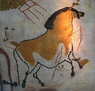 Lascaux, replica in the Brno museum Anthropos.
 -
 Entrance of the Roc de Saint-Cirq cave.
 -
 Shelter of the Cro-Magnon.
 -
 Le Grand Roc Cave


.jpg)
Related pages[change | change source]
References[change | change source]
- ↑ "Prehistoric Sites and Decorated Caves of the Vézère Valley". World Heritage Centre. UNESCO. Retrieved 11 March 2017.
Other websites[change | change source]
Wikimedia Commons has media related to Caves of Dordogne.
- Hominides.com website Archived 2009-11-24 at the Wayback Machine (in French)
- Office de tourisme de la Vallée de la Vézère (in French)