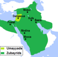
File:Approximate map of areas under Ibn al-Zubayr's control after the death of Muawiya II.png

Page contents not supported in other languages.
This is a file from the Wikimedia Commons
From Simple English Wikipedia, the free encyclopedia

Original file(6,985 × 4,449 pixels, file size: 1.83 MB, MIME type: image/png)

Summary

Description
English: Approximate map of areas under Ibn al-Zubayr's control after the death of Muawiya II.
Date
Source

Own work. Base map: [1]; Caliphate Borders: [2][3][4]; Locations: [2][3][4]; Provincial borders (modified as per Control): [2][3][5]; Control:[6][7][8][9][10][11]

[1] Demis World Map Server. [2] Robinson, C. F. (ed.) (2011) The New Cambridge History of Islam, Vol 1. Maps 3–9. [3] Kennedy, H. N. (ed.) Historical Atlas of Islam. Brill. [4] Al Ameer son. File:Second Fitna Territorial Control Map ca 686.png. [5] Malise Ruthven, Azim Nanji (2004) - Historical Atlas of Islam. Harvard University Press. p. 29. [6] Donner, F. M. (2010). Muhammad and the Believers, at the Origins of Islam. Harvard University Press. pp. 181–182. [7] Hawting, G. R. (1989) Tabari. Vol 20. SUNY press. pp. 49–51. [8] Hawting, G. R. (2000). The First Dynasty of Islam: The Umayyad Caliphate AD 661–750. Routledge. p. 48. [9] Gibb, H. A. R. (1960). "ʿAbd Allāh ibn al-Zubayr". In EI2. Vol 1. p. 55. [10] Morony, Michael (1984). Iraq After the Muslim Conquest. Princeton: Princeton University Press. pp. 134-135

[11] Rotter, Gernot (1982). Die Umayyaden und der zweite Bürgerkrieg (680–692) (in German). Wiesbaden: Deutsche Morgenländische Gesellschaft. p. 84.
Author AhmadLX

Licensing

I, the copyright holder of this work, hereby publish it under the following license:
w:en:Creative Commons
attribution share alike
This file is licensed under the Creative Commons Attribution-Share Alike 4.0 International license.
You are free:
  • to share – to copy, distribute and transmit the work
  • to remix – to adapt the work
Under the following conditions:
  • attribution – You must give appropriate credit, provide a link to the license, and indicate if changes were made. You may do so in any reasonable manner, but not in any way that suggests the licensor endorses you or your use.
  • share alike – If you remix, transform, or build upon the material, you must distribute your contributions under the same or compatible license as the original.

Captions

Approximate map of areas under Ibn al-Zubayr's control after the death of Muawiya II

Items portrayed in this file

depicts

30 May 2019

image/png

62b26a0c12511970b1afe37cdd51b66d6a44356a

1,914,215 byte

4,449 pixel

6,985 pixel

File history

Click on a date/time to view the file as it appeared at that time.

Date/TimeThumbnailDimensionsUserComment
current07:10, 15 April 2021Thumbnail for version as of 07:10, 15 April 20216,985 × 4,449 (1.83 MB)AhmadLXCorrections, enlarge, more detail
07:22, 3 June 2019Thumbnail for version as of 07:22, 3 June 2019342 × 337 (21 KB)AhmadLXHigher resolution. Color changes for consistency w.r.t to related maps.
02:21, 30 May 2019Thumbnail for version as of 02:21, 30 May 2019299 × 294 (25 KB)AhmadLXUser created page with UploadWizard

There are no pages that use this file.

Global file usage

The following other wikis use this file: