2018 Sunda Strait tsunami
(Redirected from 2018 eruption of Anak Krakatoa)
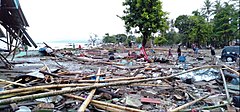
 Scene of destruction in Carita Beach, Banten after a tsunami struck | |
| Date | 22 December 2018 |
|---|---|
| Time | around 21:38 WIB (14:38 UTC) |
| Location | Sunda Strait, Indonesia |
| Coordinates | 6°06′11″S 105°25′23″E / 6.103°S 105.423°E |
| Deaths | 426[1][2] |
| Non-fatal injuries | 14,059[1] |
| Missing | 25[3] |
| Property damage | 2,752 houses and 510 ships[4] |
On 22 December 2018, a tsunami that was caused by an eruption and collapse of the Anak Krakatau volcano in the Sunda Strait struck coastal regions of Banten and Lampung, Indonesia. At least 281 people were killed and 1,016 were injured.[5] According to The Guardian, "the tsunami is believed to have been caused by undersea landslides that followed an eruption of the Anak Krakatau volcano".[6]
References[change | change source]
- ↑ 1.0 1.1 "Number of injured in Indonesia tsunami surges to over 14,000". The Star Online. Asean Plus. Retrieved 31 December 2018.
- ↑ "Indonesia Revisi Jumlah Korban Tsunami Anak Krakatau". Mata Mata Politik (in Indonesian). 29 December 2018. Archived from the original on 26 January 2019. Retrieved 26 January 2019.
- ↑ "Number of people injured by tsunami soars to 7,200". Straits Times. 2018-12-28. Retrieved 29 December 2018.
- ↑ "Number of injured in Indonesia tsunami surges to over 14,000 — Asean Plus | the Star Online".
- ↑ "Death toll from Indonesian tsunami rises to 281". www.cbsnews.com. Retrieved 2018-12-24.
- ↑ Justin McCurry; Frances Perraudin; agencies (23 December 2018). "Sunda Strait tsunami death toll likely to rise, say Indonesian officials". The Guardian. Retrieved 23 December 2018.
The tsunami is believed to have been caused by the collapse of Anak Krakatau that followed an eruption of the Anak Krakatau volcano. There were no significant seismic tremors to indicate a tsunami was coming.
