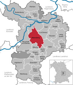
Abensberg
Abensberg | |
|---|---|
 Aerial view of Abensberg's Old Town | |
| Coordinates: 48°48′N 11°51′E / 48.800°N 11.850°E | |
| Country | Germany |
| State | Bavaria |
| Admin. region | Niederbayern |
| District | Kelheim |
| Subdivisions | 7 Ortsteile |
| Government | |
| • Mayor (2017–23) | Uwe Brandl[1] (CSU) |
| Area | |
| • Total | 60.29 km2 (23.28 sq mi) |
| Elevation | 370 m (1,210 ft) |
| Population (2022-12-31)[2] | |
| • Total | 14,534 |
| • Density | 240/km2 (620/sq mi) |
| Time zone | UTC+01:00 (CET) |
| • Summer (DST) | UTC+02:00 (CEST) |
| Postal codes | 93326 |
| Dialling codes | 09443 |
| Vehicle registration | KEH |
| Website | www.abensberg.de |

Abensberg (German pronunciation: [ˈaːbənsˌbɛʁk] (![]() listen)) is a town in Kelheim, in Bavaria, Germany, placed about 30 km southwest of Regensburg, 40 km east of Ingolstadt, 50 northwest of Landshut and 100 km north of Munich. It is on the river Abens, a tributary of the Danube.
listen)) is a town in Kelheim, in Bavaria, Germany, placed about 30 km southwest of Regensburg, 40 km east of Ingolstadt, 50 northwest of Landshut and 100 km north of Munich. It is on the river Abens, a tributary of the Danube.
Geography[change | change source]
The town is on the Abens river, a tributary of the Danube, about eight kilometres from the river's source. The area around Abensberg is by the valley of the Danube, where the Weltenburg Abbey stands, the valley of the Altmühl in the north, a left tributary of the Danube, and the famous Hallertau hops-planting region in the south. The town is divided into the municipalities of Abensberg, Arnhofen, Holzharlanden, Hörlbach, Offenstetten, Pullach and Sandharland.
Divisions[change | change source]
Since the administrative reforms in Bavaria in the 1970s, the town also surrounds the following Ortsteile:
- In the town: Abensberg (main settlement), Aunkofen (civil parish), Badhaus (village)
- To the east: Gaden (village), See (village), Offenstetten (civil parish)
- To the north east: Arnhofen (civil parish), Baiern (village), Pullach (civil parish), Kleedorf (village)
- To the north: Sandharlanden (civil parish), Holzharlanden (civil parish), Buchhof (small hamlet)
- To the west: Schwaighausen (village), Schillhof (hamlet), Gilla (small hamlet)
- To the south: Aumühle (small hamlet), Allersdorf (hamlet)
- To the south east: Lehen (small hamlet), Mitterhörlbach (hamlet), Upper Hörlbach (village), Lower Hörlbach (hamlet)
References[change | change source]
- ↑ Liste der ersten Bürgermeister/Oberbürgermeister in kreisangehörigen Gemeinden, Bayerisches Landesamt für Statistik, accessed 19 July 2021.
- ↑ Genesis Online-Datenbank des Bayerischen Landesamtes für Statistik Tabelle 12411-003r Fortschreibung des Bevölkerungsstandes: Gemeinden, Stichtag (Einwohnerzahlen auf Grundlage des Zensus 2011)


