
Aitrang
Aitrang | |
|---|---|
 Aitrang seen from the southeast | |
 Coat of arms | |
Location of Aitrang within Ostallgäu district  | |
 Aitrang  Aitrang | |
| Coordinates: 47°49′N 10°32′E / 47.817°N 10.533°E | |
| Country | Germany |
| State | Bavaria |
| Admin. region | Schwaben |
| District | Ostallgäu |
| Government | |
| • Mayor (2020–26) | Michael Hailand[1] |
| Area | |
| • Total | 30.71 km2 (11.86 sq mi) |
| Elevation | 745 m (2,444 ft) |
| Population (2022-12-31)[2] | |
| • Total | 2,088 |
| • Density | 68/km2 (180/sq mi) |
| Time zone | UTC+01:00 (CET) |
| • Summer (DST) | UTC+02:00 (CEST) |
| Postal codes | 87648 |
| Dialling codes | 08343 |
| Vehicle registration | OAL |
| Website | www.aitrang.de |
Aitrang is a municipality in Ostallgäu in Bavaria in Germany.
Geography[change | change source]
Aitrang is in the south Bavarian Region Allgäu.
It surrounds districts of: Aitrang, Huttenwang, Wenglingen. Administrative responsibility also extends to the distant villages of Binnings, Goerwangs, Krähberg, Neuenried, Wolfholz, Münzenried and Umwangs as well as several Farms. Aitrang also covers the Eibsee (lake).
Picture Gallery[change | change source]
-
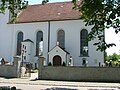 Pfarrkirche St.Ulrich
 -
 Sehenswertes Giebelfries
 -
 Ortsmitte mit Linde
 -
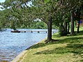 Elbsee südlich von Aitrang


References[change | change source]
- ↑ Liste der ersten Bürgermeister/Oberbürgermeister in kreisangehörigen Gemeinden, Bayerisches Landesamt für Statistik, 15 July 2021.
- ↑ Genesis Online-Datenbank des Bayerischen Landesamtes für Statistik Tabelle 12411-003r Fortschreibung des Bevölkerungsstandes: Gemeinden, Stichtag (Einwohnerzahlen auf Grundlage des Zensus 2011)
Other websites[change | change source]
Wikimedia Commons has media related to Aitrang.
- Website of the municipality Aitrang
- Warburg Institute Iconographic Database (images of the interior of St Alban's church) Archived 2016-03-04 at the Wayback Machine
Towns and municipalities in Ostallgäu | ||
|---|---|---|
|  | |
| International | |
|---|---|
| National | |
| Geographic | |