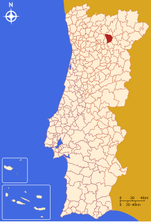
Alijó
Alijó | |
|---|---|
 Part of the landscape of Pinhão, which motivated the classification parts of Alijó as UNESCO World Heritage Site | |
 | |
| Coordinates: 41°16′34″N 7°28′30″W / 41.27611°N 7.47500°W | |
| Country | |
| Region | Norte |
| Intermunic. comm. | Douro |
| District | Vila Real |
| Parishes | 14 |
| Government | |
| • President | José Rodrigues Paredes (PSD) |
| Area | |
| • Total | 297.60 km2 (114.90 sq mi) |
| Elevation | 739 m (2,425 ft) |
| Population (2011) | |
| • Total | 11,942 |
| • Density | 40/km2 (100/sq mi) |
| Time zone | UTC±00:00 (WET) |
| • Summer (DST) | UTC+01:00 (WEST) |
| Postal code | 5070 |
| Area code | 259 |
| Patron | Santa Maria Maior |
| Website | http://www.cm-alijo.pt |
Alijó (Portuguese pronunciation: [ɐliˈʒɔ] (![]() listen)) is a city in the Norte Region of Portugal. It is in the district of Vila Real. The population in 2011 was 11,942.[1][2]
listen)) is a city in the Norte Region of Portugal. It is in the district of Vila Real. The population in 2011 was 11,942.[1][2]
References[change | change source]
- ↑ Instituto Nacional de Estatística
- ↑ "Áreas das freguesias, concelhos, distritos e país". Archived from the original on 2018-11-05. Retrieved 2018-11-05.


